
Horsenden Hill is the highest point in the London Borough of Ealing, 84 metres above sea level by the council's own figure, and under the grass on the summit is a scheduled ancient monument. It is free, it is open country rather than a park, and it is about seventeen minutes' walk from Perivale station on the Central line.
The first thing to correct is the monument. Horsenden Hill is often described as an Iron Age hill fort. Historic England's designation, which is the document that decides the matter, describes it as an Iron Age settlement: list entry 1001970, "Iron Age settlement on Horsenden Hill, Greenford", scheduled on 8 March 1976 and covering just over three hectares of the summit.
The second thing to know is that this is one of the largest pieces of working countryside inside London. Ealing grazes cattle on it, there is a farm at the foot of the hill, and the Grand Union Canal runs along the western edge. Our guide to Ealing and west London puts it among the other reasons to come out this far.
Horsenden Hill at a glance
- Price
- Free, with no gate and no ticket
- Height
- 84 metres at the summit, the highest point in Ealing (Ealing Council)
- Designation
- Scheduled monument 1001970, an Iron Age settlement, 3.03 hectares, scheduled 8 March 1976
- Walk from Perivale
- 17 minutes to the summit; 13 minutes to Horsenden Farm (Transport for London walking planner)
- Walk from Sudbury Town
- 20 minutes to the summit
- Bus
- Route 297, from Wembley, Ealing and Willesden, stops near the farm
- Car park
- At Horsenden Farm, UB6 7PQ, free and open every day except event days. Closes 4.30pm November to February and 8pm May to August
Settlement, not hill fort: what the designation actually says
The scheduled monument sits at the summit and looks south over the Grand Union Canal and Perivale. Historic England summarises it as an Iron Age settlement 347 metres north-north-west of Horsenden Farm, covering a semi-circular area more than 150 metres across.
What survives above ground is very slight. The list entry records possible traces of defensive ditches and banks on the west and south sides of the hill, appearing as slight undulations in the ground surface, and says the earthworks are likely to survive as buried remains, having been part-levelled and infilled in the past. In other words: you will not see ramparts. You will walk over a broad grassy dome and, if you look along the western and southern slopes with the low sun behind you, you may pick out the undulations.
The reason the word "hill fort" attaches to the place is that Historic England's designation text includes a general description of the monument class, which covers small multivallate hillforts as well as enclosed farmsteads. The actual designation here is the settlement.
Walk the west and south slopes, not just the top. The undulations that the designation describes are on those sides, and low light in winter is when a slight earthwork shows. From the flat summit itself there is nothing archaeological to see at all, which is why people go away thinking there is nothing there.
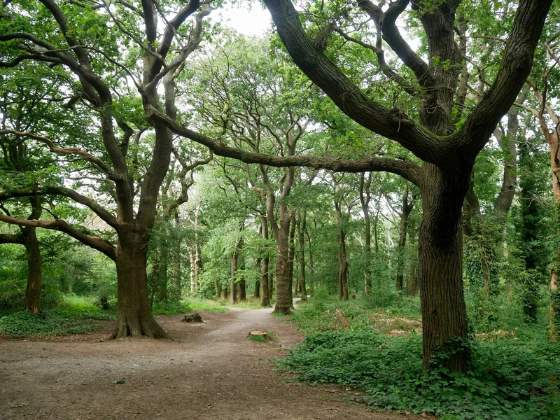
Photo: Doyle of London · CC BY-SA 4.0 · Wikimedia Commons · resized
What came out of the ground
The hill has been excavated three times: partially in 1973–77, again in 1987–88, and again in 1995. The finds are the most interesting thing on the page, because they show the summit was in use for a very long time.
- Iron Age: a considerable quantity of pottery, and an enamelled lynchpin — the pin that holds a wheel on an axle, decorated, which is not a farming object.
- Neolithic: worked flint, including a transverse arrowhead and a retouched blade fragment.
- Bronze Age, Roman and medieval: pottery sherds from all three.
Only part of the site has been excavated, which is one of the reasons Historic England gives for the designation: there is potential for further work on how the settlement was built and occupied, and on the landscape around it.
Three Horsendens, and which one you want
Ealing divides the site into three parts, and they are genuinely different places.
| Section | What it is | Go there for |
|---|---|---|
| Horsenden East | Bordered by Horsenden Lane North. Large areas of woodland with smaller patches of grassland, managed by grazing cattle on the fields | The summit, the scheduled monument and the view. This is the hill |
| Horsenden West | The other side of the lane, bordered by the Grand Union Canal. A mosaic of wildflower meadows, hedgerows and ponds | Flowers and insects in June and July; the flattest walking on the site |
| Paradise Fields | South of the canal. Scrapes, reed beds and lagoons | Birds, and a wetland that most Londoners have never heard of |
The council describes the whole as ancient woodland, grassland, ponds and hedgerows. That is accurate, and it is worth saying what it is not: there are no formal gardens, no bandstand, no lake with boats and no café run by the park. This is a nature reserve with a hill in it.
Getting there, and the station that is not obvious
Perivale, on the Central line, is the right station. Transport for London's walking planner gives seventeen minutes from the station to the summit and thirteen minutes to Horsenden Farm at the foot of the hill, and the difference between those two numbers is almost all gradient rather than distance.
Sudbury Town, on the Piccadilly line, is twenty minutes to the summit and comes at the hill from the north-east. Greenford, also on the Central line, is twenty-seven minutes and is the wrong choice unless you want to walk the canal. Our guide to the Central line covers the journey out from town, which is about half an hour from Oxford Circus.
Bus route 297, from Wembley, Ealing and Willesden, stops near the farm, and it is the answer if the climb from the station is the problem. If you are on the water, there is normally public mooring space by Ballot Box Bridge on the Grand Union Canal, which is the crossing at the foot of the hill.
The car park closes with the season
There is a free public car park at Horsenden Farm, UB6 7PQ, open every day of the year except event days, when the spaces are restricted to Blue Badge holders and event vehicles. Its closing time follows the season rather than the clock, and this is the rule that catches people out on a winter afternoon. The times below were read on the farm's own website in September 2026.
| Months | Car park closes |
|---|---|
| November to February | 4.30pm |
| March and October | 6pm |
| April and September | 7pm |
| May to August | 8pm |
The hill itself has no gates and no closing time. The car park does, and so does the farm. If you drive out in January, be back at the car by half past four.
Cattle, dogs and what is off limits
Ealing grazes cattle in the fields on Horsenden East, and the farm's own pages name Longmead and Homemead as the meadows where the cows are usually to be seen. That is the single most important practical fact for anyone with a dog: keep it under close control, keep well clear of cattle, and use the gates rather than the gaps.
At the farm, the animal pens and the growing areas are working parts of a farm and are not open to visitors. The rest of it is: toilets with baby changing and step-free access, a playground with a pirate ship, picnic tables, a tap for filling a dog's bowl, a sensory garden and bird feeders. That was the position on the farm's own website in September 2026.
There is a bakery and café at the farm, the Horsenden Loaf, which holds a food hygiene rating of 4 from an inspection on 15 May 2026. Its published hours are narrow: Fridays 11am to 2pm, and Saturdays and Sundays 10am to 4pm. On a Tuesday there is nothing to eat on the whole site, so bring something.
The view, and why it has no legal protection
Ealing calls the views from the summit amazing and does not describe them, and we could find no official description of what is visible. So take the compass rather than a promise. You are on a broad grassy dome with trees on several sides, which means the panorama is not continuous: you walk round the top and it opens in sections. Wembley and the arch of the stadium lie roughly east-north-east, three kilometres off. Harrow on the Hill lies north-north-west, and the Chiltern ridge lies on the same bearing far beyond it. Central London is to the east-south-east, sixteen kilometres away. How much of any of it you see depends on the haze and on which side of the trees you are standing.
None of it is protected. The Mayor of London's London View Management Framework, whose 2026 draft went out for consultation on 11 September 2026, designates 28 viewing places across London, and Horsenden Hill is not among them, any more than Telegraph Hill in New Cross is. The protected list is almost entirely central and north London, plus Greenwich and Richmond.
For a comparison on the same side of town, Harrow on the Hill is the other high point out here and has a churchyard view that is better known; and our page on getting to Wembley Stadium covers the arch you can see from the top.
The best route combines the hill with the canal rather than doubling back. Come out of Perivale, climb over the summit, drop down to the Grand Union at Ballot Box Bridge, and walk the towpath. It is flat, it is surfaced, and it takes you past Paradise Fields. The towpath is the one part of this outing that a wheelchair or a pushchair can manage comfortably; the hill is grass and mud.
A pub, and the bridge named after it
At the foot of the hill, by the canal, the Ballot Box holds a food hygiene rating of 5 from an inspection on 16 November 2024. It is the pub the canal bridge is named after, which tells you how long there has been one here, and it is the only place within easy reach of the summit that is open on an ordinary weekday.
The Grand Union here is the same waterway that runs into London at Little Venice; our page on the Paddington Arm covers the towpath from this side of town into the middle of it, and walking in London explains where the towpaths beat the Tube. If you are making a day of Ealing, Pitzhanger Manor is the borough's other reason to get off the train.
Beyond that, the food is in Greenford or Perivale, and our guide to London's beer gardens makes the general point that a canalside pub in outer London on a summer evening is a better proposition than most central ones. The hill itself, being free, belongs on our list of free things to do in London.
Frequently asked questions
Is there really an Iron Age hill fort on Horsenden Hill?
Not according to the designation. Historic England scheduled the summit in March 1976 as an Iron Age settlement, not a hillfort, covering just over three hectares. There are possible traces of defensive ditches and banks on the west and south slopes, but the earthworks survive mainly as buried remains.
How high is Horsenden Hill?
Ealing Council gives the summit as 84 metres above sea level and describes it as the highest point in the borough. Other published figures round it to 85 metres; we have used the council's own number.
What is the nearest station to Horsenden Hill?
Perivale, on the Central line, about seventeen minutes' walk to the summit and thirteen to Horsenden Farm. Sudbury Town on the Piccadilly line is twenty minutes to the summit. Bus route 297 stops near the farm and saves the climb from the station.
Can you drive to Horsenden Hill?
Yes. There is a free car park at Horsenden Farm, UB6 7PQ, open every day except event days, when it is restricted to Blue Badge holders and event vehicles. It closes at 4.30pm from November to February and at 8pm from May to August, with 6pm and 7pm in the months between.
Are there cattle on Horsenden Hill?
Yes. Ealing manages the grassland on Horsenden East by grazing cattle, and the farm names Longmead and Homemead as the meadows where they are usually seen. Keep dogs under close control and give the cattle a wide berth, particularly with calves about.
Sources
- Ealing Council – Horsenden Hill: the three sections, cattle grazing and the 84-metre summit as the borough's highest point (checked September 2026)
- Historic England – list entry 1001970, Iron Age settlement on Horsenden Hill, Greenford: designation, excavations and finds (Internet Archive copy of 27 March 2025) (checked September 2026)
- Historic England – National Heritage List for England open data (scheduling date 8 March 1976; area 3.03 hectares) (checked September 2026)
- Transport for London – journey planner, walking times from the summit to Perivale, Sudbury Town and Greenford (checked September 2026)
- Greater London Authority – London View Management Framework 2026 consultation GIS files: the 28 designated viewing places, which do not include Horsenden Hill (checked September 2026)
- Food Standards Agency – food hygiene rating register (The Ballot Box, UB6 7QL, rated 5 on 16 November 2024; The Horsenden Loaf, Horsenden Farm UB6 7PQ, rated 4 on 15 May 2026) (checked September 2026)