
The Point, at the top of Point Hill in west Greenwich, is a scrap of grass and trees with a railing along its northern edge, and the panorama from it is one of 28 views that the Mayor of London protects by planning policy. It is free, it has no gate staff and no ticket, it is almost never crowded, and it is a twelve-minute walk uphill from Greenwich station.
The Mayor's framework calls it Blackheath Point, because it sits on the Greenwich side of the ridge that carries Blackheath. On the ground it is signed as The Point, at the junction of Point Hill and West Grove, SE10.
Our guide to Greenwich Park covers the famous version of this view, from the terrace by General Wolfe's statue, and explains the climb and the crowds there. This page is about the other one, half a mile west, which most visitors to Greenwich never hear about.
The Point, Point Hill SE10
- Price
- Free. No ticket, no booking, no staff
- Official designation
- London View Management Framework viewing place 6, Blackheath Point; representative viewpoint 06A, "the orientation board"
- Height of the viewpoint
- 45.96 metres, on a bearing of 304.9 degrees
- Walk from Greenwich station
- 12 minutes, uphill (Transport for London journey planner, walking)
- Walk from Cutty Sark DLR
- 16 minutes, uphill
- Walk from Blackheath station
- 19 minutes, mostly level
- Opening hours
- None published that we could find. See the section below
What "protected view" actually means here
The Mayor of London keeps a list of views that planning applications have to be tested against, called the London View Management Framework. The current draft was published for public consultation on 11 September 2026, and its own mapping files list 28 designated viewing places and 52 representative viewpoints across London.
Blackheath Point is number 6 on that list, and its representative viewpoint 06A is described in the data as "the orientation board". That is not a vague area: the framework records a single spot, 45.96 metres above sea level, facing 304.9 degrees. Plot that bearing on a map and it runs to St Paul's Cathedral, seven and a half kilometres away.
Three planning designations radiate out from that spot. A Landmark Viewing Corridor, which is the protected sightline itself, and which developments may not block. Two Lateral Assessment Areas either side of it, where new buildings are assessed for the way they crowd the landmark. And a Background Consultation Area behind it, covering what may appear over the top. In other words: the reason you can still see the dome of St Paul's from a small patch of grass in Greenwich is a line drawn on a map at City Hall.
Ten of the 28 viewing places have a protected vista at all, and only seven carry the full set of corridor, lateral areas and background area. Blackheath Point is one of the seven; so is Greenwich Park, and the others are Alexandra Palace, Parliament Hill, Kenwood, Primrose Hill and King Henry's Mound in Richmond Park. That is the company this patch of grass keeps.
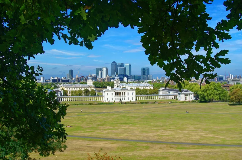
Photo: Txllxt TxllxT · CC BY-SA 4.0 · Wikimedia Commons · resized
Point Hill against the Observatory terrace
If you have half an hour and can only do one, the honest answer for a first-time visitor is the Observatory terrace, because it is where the Naval College, the Queen's House and the river line up in one composition and because you are already going to Greenwich Park for other reasons.
Come to The Point instead if you have been to Greenwich before, if you want a photograph without a hundred other people in it, or if you are interested in the view rather than the postcard. The numbers are closer than you would expect. The framework puts the Wolfe Promenade in Greenwich Park at 46.56 metres and Blackheath Point at 45.96 metres, so the two viewpoints are within about two feet of each other in height.
What differs is the angle and the foreground. The Observatory looks down the axis of the park at 298.9 degrees, with the colonnades below. From The Point, at 304.9 degrees, you are looking over the roofs of the town itself: the streets of west Greenwich in the near distance, then Deptford and the river, then the towers. Canary Wharf sits to the right, the City ahead, and on a clear afternoon the dome of St Paul's shows in the gap the corridor protects.
The name in the data is the practical tip. The framework fixes the viewpoint at "the orientation board", which tells you where to stand: at the railing, beside the board, rather than anywhere on the grass. Step ten metres left or right and trees take the sightline. The board itself is worth a minute, though it is not a substitute for a phone: it identifies the skyline as it was when the board was made, which was well before most of the towers you can see.
Getting up there, and which way to walk
From Greenwich station, served by the DLR and by Southeastern trains, go south down Greenwich High Road and turn up Royal Hill. It is twelve minutes on Transport for London's walking planner, and it is a genuine climb: Royal Hill, Point Hill and West Grove rise steadily from the level of the town to the top of the ridge. There are pavements all the way and no steps on that route.
From Cutty Sark DLR, at the ship, allow sixteen minutes and rather more climbing. From Blackheath station the walk is nineteen minutes but almost flat, coming along the edge of the heath and down West Grove, which is the route to choose with a pushchair, with a wheelchair or with anyone who does not want the hill.
Once you are there, the ground itself is grass and rough path on a slope, with the railing and the board at the top. It is not a levelled viewing platform. Someone in a wheelchair can reach the railing from West Grove, but the grass beyond it is uneven and the site has no surfaced circuit.
Opening hours: an honest gap
We could not establish a published opening or closing time for The Point. The Royal Borough of Greenwich's own directory of parks and open spaces would not serve us its pages in September 2026, and no other official source we could read gives hours for this site.
What we can say is what the designation implies and what the geography shows: this is a small public open space on a public street corner, not a walled park with a keeper. Treat the hours as unknown rather than as unlimited, plan a daylight visit, and if you want a sunset view check our round-up of London's best free viewpoints for the sites where the closing rule is published.
Point House, and the man who invented the postage stamp
The building that dominates the top of the hill is Point House, 18 West Grove, and it is listed at Grade II*, the second-highest grade, entered on the national list on 8 June 1973. The core of it is of 1701, with later wings.
Historic England's description is unusually rich, and it is worth knowing what to look at from the pavement. Three storeys and a basement of multi-coloured stock brick, five windows wide, with a stone-coped parapet hiding the roof and urn finials over the slightly projecting centre. Rusticated stone quoins on the ground and first floors. A heavy moulded cornice at second-floor level, broken in the middle by a pediment with an oriel window set into it — and that oriel is modern, replaced after war damage, though an original survives on the back wall. The door sits in a Doric doorcase with a triglyph frieze and a segmental pediment. The list entry notes that the whole second floor may be a later addition, because the window arches there are flat while those below are segmental.
And the fact that makes the house worth a paragraph rather than a line: it was once lived in by Rowland Hill, the man behind the penny post. The view he had from those windows is the one you are standing in.
The listed stone in the corner
The other listed thing here is easy to miss and takes ten seconds to find once you know. A boundary stone at the north-west corner of Point Hill is listed in its own right at Grade II, on the same date in June 1973 as the house. It is the sort of object that survives because somebody in 1973 wrote it down.
West Grove and Dartmouth Row, running east along the ridge towards Blackheath, hold a dozen more listed buildings, including Grove House and Manna Mead, the second of them at Grade II*. If you like walking through listed streets rather than round monuments, this is one of the better half-miles in south-east London, and it ends at the heath. Our guide to Blackheath picks the walk up from there.
What the view gives you, month by month
The trees are the variable. In winter the view opens out and the sightline is at its widest; from late spring the canopy below the railing closes in and you are looking through a frame rather than over a sill. Photographers come in February and November for that reason.
Light matters more here than at the Observatory. You are facing north-west, so the sun is behind the towers in the middle of the day and behind you in the early morning. Late afternoon and the hour before sunset are when the City and Canary Wharf light up and the foreground is still readable; at midday in summer the whole thing flattens into haze.
On an ordinary London day you will see to the City and no further, which is still the point.
Combine it with the park rather than choosing between them. Walk up Royal Hill to The Point, along West Grove and Dartmouth Row to the edge of Blackheath, then into Greenwich Park through Blackheath Gate and down the hill past the Observatory terrace. That is roughly two and a half miles, it takes in both protected viewpoints, and the second half is downhill. Our page on the Royal Observatory and Cutty Sark has the ticket detail, and note that the Observatory closes from 2 November 2026 until summer 2027 — the terrace and the view stay open.
A drink at the bottom of the hill
There is nothing to eat or drink at The Point, and no toilet. Go back down into the town.
The one place worth naming on the way down is the Morden Arms, a corner pub at 1 Brand Street about five minutes below the hill and listed at Grade II in its own right. It holds a food hygiene rating of 4 from an inspection on 27 June 2025. Beyond that, our guide to eating in Greenwich covers the town and the market.
The Point costs nothing, which puts it on our list of free things to do in London. If you like this kind of view, the closest equivalent is Telegraph Hill in New Cross, two miles west along the same ridge and just as empty; staying in Greenwich explains why this side of the town is the quieter half.
Frequently asked questions
Is the view from Point Hill better than from the Royal Observatory?
It is a different view of the same city from almost exactly the same height: the Mayor's own data puts the Observatory terrace at 46.56 metres and Blackheath Point at 45.96. The Observatory frames the Naval College and the river; The Point looks over the roofs of west Greenwich towards the City. The Point is far quieter, and both are free.
Where exactly should you stand at The Point?
At the railing beside the orientation board. The Mayor's framework fixes the official viewpoint there, which is also where the trees leave the sightline clear. A few metres to either side and the foliage closes the gap.
How do you get to Point Hill from central London?
Take the DLR or a train to Greenwich, then walk up Royal Hill and Point Hill, about twelve minutes and a real climb. If you would rather avoid the hill, go to Blackheath by train instead and walk down West Grove, which takes about nineteen minutes and is nearly flat.
Is The Point open at night?
We could not find any published opening or closing hours for it, and we are not going to guess. It reads as an open street-corner space rather than a gated park. Plan a daylight visit, and use a viewpoint with published hours if you want to be out after dark.
What is Point House?
A Grade II* listed house of 1701 with later wings, at 18 West Grove, at the top of the hill. Historic England's list entry records early eighteenth-century panelling and a wide carved staircase inside, notes that the oriel window in the centre of the front is a post-war replacement, and records that Rowland Hill, the founder of the penny post, once lived there.
Sources
- Greater London Authority – London View Management Framework 2026 consultation GIS files: representative viewpoints and protected vistas (Blackheath Point, viewing place 6, viewpoint 06A) (checked September 2026)
- Historic England – National Heritage List for England open data (Point House 1289615; boundary stone at Point Hill 1079051; Grove House 1212232; Manna Mead 1212240) (checked September 2026)
- Historic England – list entry 1289615, Point House, 18 West Grove SE10 (Internet Archive copy of 6 March 2026) (checked September 2026)
- Transport for London – journey planner, walking times from The Point to Greenwich, Cutty Sark and Blackheath (checked September 2026)
- Food Standards Agency – food hygiene rating register (The Morden Arms, 1 Brand Street SE10 8SP, rated 4 on 27 June 2025) (checked September 2026)