
The Thames Barrier is the line of steel gates across the river at Woolwich that stops storm surges from the North Sea reaching central London. It has been closed 221 times for flood defence since it started work in 1982, it is tested once a month, and the long annual test in 2026 falls on Sunday 11 October. You cannot go onto the Barrier itself, but you can watch it from either bank for nothing.
From a distance it looks like a row of silver shells sitting in the water. Those hoods are the machinery housings. Between them, lying flat on the riverbed most of the time, are ten gates that swing up when London is at risk. Raised, the main gates stand as high as a five-storey building and are as wide as the opening of Tower Bridge, and each one weighs 3,300 tonnes.
It is a working piece of infrastructure rather than an attraction, which is exactly why it is worth the journey east. This page covers what it does, when it moves, where to stand, and what the small Saturday-only Information Centre gets you.
The Thames Barrier in brief
- What it is
- A movable flood barrier across the Thames near Woolwich, run by the Environment Agency
- Size
- 520 metres across the river; 10 steel gates; protects 125 square kilometres of central London
- Opened
- Operational from 1982; officially opened by the late Queen on 8 May 1984
- Closures
- 221 times for flood defence, correct to 17 November 2025
- Next long test closure
- Sunday 11 October 2026, river closed roughly 08:05 to 18:05
- Information Centre
- Saturdays only, 4 April to 31 October 2026, tickets sold at the door 10:30 to 15:30. Adult £6.00, child £4.80
- Address
- 1 Unity Way, Woolwich, London SE18 5NJ (south bank)
- Watching from the north bank
- Thames Barrier Park, free, open daily from dawn until dusk; Pontoon Dock on the DLR
The two kinds of flood it stops
Most visitors assume the Barrier is there for heavy rain. It is not, or not mainly. Its first job is tidal: when a storm in the North Sea pushes a surge of water up the Thames estuary on top of a high spring tide, the gates close and central London stays dry behind them.
The second job is the river. When a great deal of water is coming downstream, measured as it passes over Teddington Weir far to the west, the Barrier can also be closed to hold the tide out and give the river room to drain. The Environment Agency says this reduces the flood risk in parts of west London including Richmond and Twickenham, which is a long way from Woolwich and surprises people.
The decision is not automatic and there is no single trigger level. Forecasters can see dangerous conditions up to 36 hours ahead using tide gauges, Met Office data and river-flow readings, and a duty controller makes the call. The gates usually close just after low tide, about four hours before the peak of the surge reaches the Barrier, and stay shut over high water. Reopening is a managed process that takes around five hours, letting the water upstream run out with the outgoing tide.
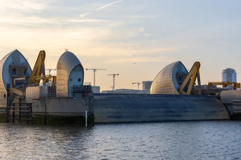
Photo: The wub · CC BY-SA 4.0 · Wikimedia Commons · resized
How often it has actually closed
The Environment Agency keeps a running total. As at 17 November 2025, the Barrier had been closed 221 times for flood defence purposes since 1982: 119 of those against tidal flooding, and 102 against a combination of tide and river flow.
Spread over more than forty years that is an average of about five closures a year, but the closures do not arrive evenly. They cluster in winter storm seasons, and some years pass with very few. If you want to see the gates up, the odds in an average summer week are poor and the odds in a February gale are better, which is not a holiday plan most people want to make.
The number also explains why the Barrier matters more than its size suggests. Behind it sit 1.42 million people and, on the Environment Agency's own figure, £321 billion of residential property.
The monthly tests, and the long one in October
You do not have to wait for a storm. The gates are raised once a month for maintenance and testing, and the Environment Agency publishes the dates and times in advance on its Thames Barrier guidance page.
Most tests are short. Through 2026 the monthly closures have run for about two and a half hours, usually starting mid-morning: 09:45 in September, 10:30 in August, 11:15 in July. One test each year is much longer. In 2026 it falls on Sunday 11 October, with the river closed from roughly 08:05 until 18:05, ten hours rather than two and a half. In previous years the Agency has described the October closure as the Barrier's annual closure, and it is the date to plan around if you want to see the gates rise and fall again in daylight.
A test closure can be called off on the day. The Environment Agency warns that times may change because of an experiment, a piece of engineering work or the weather, that the gates may start moving up to an hour before the published time, and that a monthly test is occasionally cancelled altogether if the Barrier has already been closed that month for flood or navigation reasons. Check the gov.uk page the day before, and do not build a long journey around it alone.
Where to stand on the south bank
The Barrier's own site is on the south side of the river, between Charlton and Woolwich. The riverside path runs right along it, and the view from there is the close one: you are level with the piers, looking along the line of hoods rather than at them.
This stretch is part of the Thames Path National Trail, which was inaugurated at the Barrier in 1996 and now continues east towards the Kent coast. Walking in from Greenwich along the river takes a little over an hour and is the most satisfying way to arrive, because the Barrier appears gradually rather than all at once. The stretches either side are described in our guide to walking the Thames Path through London.
The Environment Agency keeps the outside toilets, the disabled lift and the car parks open seven days a week between 09:00 and 17:00, even on the days the Information Centre itself is shut. That makes a walk past the Barrier practical on any day of the week.
Thames Barrier Park, on the north bank
The better view is from the other side. Thames Barrier Park sits directly opposite, in the Royal Docks, and it looks straight down the line of the gates. It is free, it is open every day from dawn until dusk, and it has a play area, an outdoor gym, a ball court and toilets, which makes it the easier half of the trip with children.
The park's own design is worth a look on its own account: a long sunken garden cut diagonally through the lawns, with clipped hedges, below the level of the surrounding ground. Pontoon Dock on the DLR is a few minutes away; if you have not used that network before, our page on the DLR and the Overground covers how it differs from the Tube.
Both riverside views cost nothing. You do not need a ticket for either bank, and the Barrier looks its best from outside rather than from inside the exhibition. If money is the deciding factor, come on any day, walk the south bank or the park, and skip the Information Centre entirely. There are more days out of this kind in our round-up of London without a ticket.
The Information Centre, and what £6 gets you
The Thames Barrier Information Centre, known as The View, is a small exhibition on the south bank with a working model of the Barrier, a virtual technical tour, and films and displays about flooding and the river environment. The entrance is downstairs, near the car park.
Its opening is narrow, and this is the detail most guides get wrong. For 2026 it opens only on Saturdays, between 4 April and 31 October. There is no need to book: tickets are sold at the entrance between 10:30 and 15:30. The Environment Agency has not published a reopening date beyond 31 October, so if you are visiting in winter, email ahead rather than travelling on spec.
| Ticket | Price (2026) |
|---|---|
| Adult | £6.00 |
| Senior or student | £5.50 |
| Child | £4.80; under-5s free |
| Disabled visitor | £4.50 |
| Family (2 adults and up to 3 children) | £16.00 |
Groups are treated separately and can book on any day of the week, with at least a week's notice. The packages are priced per group rather than per head, from £204.00 for up to fifteen people to £290.00 for a technical presentation for up to thirty people aged 16 and over. Each group gets a guide who walks them round the Barrier estate.
Nobody goes out onto the Barrier itself. The Environment Agency states this plainly: there is no access onto the structure, for group visits or for anyone else. What you are buying with a ticket is the exhibition and, with a group booking, a guided walk around the estate. The gates are always seen from the bank.
Getting there, and the part that catches people out
There is no station at the Barrier, and that is the one thing to plan for. On the south side, Charlton is about a mile away on foot along Woolwich Road, and Woolwich Dockyard is within walking distance; Woolwich Arsenal is the station the Environment Agency suggests if you would rather take a taxi the last stretch. North Greenwich on the Jubilee line is about two miles away, with buses 161 and 472 covering the gap. Buses 177 and 180 come through Greenwich and stop at the top of Eastmoor Street.
On the north side it is simply Pontoon Dock, which is why families with pushchairs usually choose that bank.
The two sides are not connected at the Barrier. To cross you go upstream to the Woolwich Ferry or the Woolwich foot tunnel, both free and both explained in our guide to the ferry and the foot tunnels. Do not plan a trip that assumes you can walk over the Barrier, because you cannot.
Seeing it from the water and from the air
River buses heading downstream to Woolwich and Barking Riverside pass through the Barrier, which is the closest most visitors get to it. The gates are lowered, so the boat runs between the piers with the hoods on either side. Fares, piers and the awkward business of boat trips falling outside the daily cap are covered in our page on the Uber Boat river bus, and the sightseeing operators are compared in our guide to Thames river cruises.
From above, the cable car between Greenwich Peninsula and the Royal Docks lists the Barrier among the landmarks visible on a clear day, from up to 90 metres over the water. It is a ten-minute crossing and one of the cheapest views in London; see our guide to the London Cable Car. The O2 is beside the southern terminal if you are making a day of it, and our page on getting to The O2 covers the same corner of the river.
How long it will hold
The Barrier took eight years to build and cost £535 million, roughly £2.4 billion in today's money. Its original design life ran only to 2030. On the Environment Agency's assessment the design and build were good enough that it will go on protecting London until 2070, and the Thames Estuary 2100 plan sets out what has to happen after that, in stages, as sea levels rise.
That makes a visit now a visit to a piece of engineering in the middle of its working life rather than a monument. If that is the sort of London you like, the river has more of it: the Victorian sewage-pumping cathedral at Crossness is further downstream on the same bank, and the world's first tunnel under a navigable river is at the Brunel Museum in Rotherhithe. Upstream, our walking guide to London's bridges covers the crossings in the centre, and the foreshore itself is the subject of our guide to mudlarking, where the Barrier marks the downstream edge of the permit area. For high ground with a view back over all of it, there is Severndroog Castle in Oxleas Wood, on the hill behind Woolwich.
Frequently asked questions
Can you visit the Thames Barrier?
You can visit the site but not the structure. The Environment Agency states there is no access onto the Barrier itself. You can walk the riverside path beside it on the south bank, look across from Thames Barrier Park on the north bank, or pay to enter the small Information Centre, which in 2026 opens on Saturdays only.
How often does the Thames Barrier close?
It had closed 221 times for flood defence between 1982 and 17 November 2025, an average of about five times a year, mostly in winter. On top of that it is raised once a month for a test, with the dates published in advance by the Environment Agency.
When is the Thames Barrier annual test closure in 2026?
Sunday 11 October 2026, with the river closed from about 08:05 until 18:05. That is far longer than a normal monthly test, which lasts around two and a half hours. Times can change and closures can be cancelled, so check the gov.uk Thames Barrier page shortly before you travel.
How much does the Thames Barrier Information Centre cost?
An adult pays £6.00, a senior or student £5.50 and a child £4.80. A family rate of £16.00 covers two adults plus as many as three children. Under-5s go free and disabled visitors pay £4.50. Tickets are bought at the entrance and no advance booking is needed.
What is the nearest station to the Thames Barrier?
For the north bank and the best view, Pontoon Dock on the DLR, beside Thames Barrier Park. For the south bank and the Information Centre, Charlton is about a mile away and Woolwich Dockyard is within walking distance, with buses 177 and 180 from Greenwich and 161 and 472 from North Greenwich.
Sources
- Environment Agency - The Thames Barrier: how it works, test closures and visiting (checked September 2026)
- Environment Agency - The Thames Barrier: protecting London and the Thames Estuary for 40 years (checked September 2026)
- Greater London Authority - Visit Thames Barrier Park (checked September 2026)
- Transport for London - About the River Bus (checked September 2026)
- Transport for London - London Cable Car (checked September 2026)