
Lamb's Conduit Street runs north from Theobald's Road to Guilford Place on the eastern edge of Bloomsbury, and a long central stretch of it is closed to traffic. It has two listed pubs, around twenty independent businesses and almost no chains. It is not five minutes from the British Museum: Transport for London measures the walk at about a kilometre, or twelve to fifteen minutes, and that gap is the whole reason the street still belongs to the people who live around it.
The street is named after a water conduit and points at a hospital demolished a century ago, and both facts are still legible on the ground. Camden calls it a mixed-use street of eighteenth and early nineteenth-century brick townhouses, three to four storeys, most with shops at ground-floor level, whose mix of small independent shops "creates a lively, active townscape, which is enhanced by the pedestrianisation of a sizeable stretch".
Our page on where to eat near the British Museum owns the eating here and gives the restaurants and prices; Bloomsbury covers the district. This page is the street: what is listed, what "no chains" actually means, and which days it works.
Lamb's Conduit Street at a glance
- Where
- Theobald's Road north to Guilford Place, London WC1N, in the London Borough of Camden
- Named after
- A conduit provided by William Lambe in 1577 to carry water to the City, removed in 1746
- Laid out
- By Nicholas Barbon in 1690, completed by about 1710
- Listed buildings
- Fourteen entries on the street, including both pubs; number 49 is grade II*
- From Russell Square station
- 520 m, about 7 minutes to the north end
- From Holborn station
- 576 m, about 11 minutes to the south end
- From the British Museum gates
- About 1,030 m, 12 to 15 minutes
- Quietest day
- Sunday, when the office and hospital trade that supports the street is absent
The pedestrianised stretch, and what it means in practice
The closure is long-standing rather than a recent traffic scheme: Camden's Bloomsbury conservation area appraisal already described a "sizeable stretch" as pedestrianised when it was adopted in 2011, and lists bollards, granite kerbs and a lamp post at the north end among the street's character features. Camden does not publish the exact extent in that document, so the practical test is the one you can see: no through traffic in the middle, tables and bicycles on the carriageway, and vehicles turning in only at the ends.
What that gives a visitor is unusual for central London. There is no kerb to negotiate for most of the length, the noise is conversational rather than automotive, and the shops put stock and seating out on the carriageway because they can. The surface is hard landscaping throughout, level and easy, with street trees only at the northern end, which makes this one of the more comfortable Bloomsbury streets for a pushchair or a wheelchair once you have got to it.
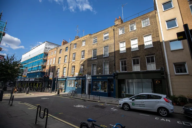
Photo: Jwslubbock · CC BY-SA 4.0 · Wikimedia Commons · resized
The conduit, and the stone still fixed to a wall
The name is literal. Camden records a water conduit provided by William Lambe in 1577 to convey water to the City; it was removed in 1746. Nicholas Barbon laid the street out in 1690 and it was finished by about 1710, and in the reign of Queen Anne it was a favourite promenade for Londoners, which is worth holding in mind when you look at the width of the pavements.
Two traces of the water survive and almost nobody looks at them. Camden's schedule of streetscape features lists a "stone surround from former pump on flank wall to entrance to Long Yard": a doorway-shaped piece of stonework on the side wall at the mouth of the little yard off the east side, left behind when the pump went. And the name survives on Lamb's Conduit Passage at the southern end, the last of seven narrow passages that led off Red Lion Square when it was begun in 1684. North of Guilford Place, Hunter Street follows the line of an old track running north from the conduit, so the water supply is still setting the street pattern three centuries after it was dug up.
Why the street widens at the top: the Foundling Hospital
Walk to the northern end and the street opens out at Guilford Place before it stops. That is not a design flourish. Lamb's Conduit Street was the approach road to the Foundling Hospital for destitute children, built in 1745 at the end of what was then Red Lion Lane, and the widening is what is left of a formal, grand approach to it.
The hospital has gone: Theodore Jacobsen's building was demolished in 1926, so, as Camden's appraisal puts it, the suggestion of that approach remains but is no longer terminated by a centrepiece building. What faces you instead is Coram's Fields, on the hospital's grounds, whose front range was laid out by the London County Council in 1936 and is listed at grade II: two wings of low-rise accommodation screening a children's playground, with eighteenth-century colonnades surviving to east and west. Adults are admitted only with a child, as our page on Coram's Fields and central London playgrounds explains.
The hospital shaped the rest of the neighbourhood too. In 1790 it raised money by releasing spare land for house building, which produced Brunswick and Mecklenburgh squares and the grid of streets around them, many built by James Burton. Its own story and collection are the subject of the Foundling Museum, five minutes north, and the squares are covered in Bedford Square and the Bloomsbury squares. Guilford Place itself holds a listed drinking fountain and a listed pair of former underground public conveniences, whose railings are what the street widens around.
What is listed, and one thing Camden's own list gets wrong
Fourteen entries in the National Heritage List for England sit on this street, which is a high count for a few hundred metres, and most were listed in a single round on 14 May 1974.
| Address | Grade | List entry | First listed |
|---|---|---|---|
| 49 Lamb's Conduit Street | II* | 1379271 | 14 May 1974 |
| 29 to 37 Lamb's Conduit Street | II | 1379268 | 14 May 1974 |
| 43 Lamb's Conduit Street and railings | II | 1379269 | 14 May 1974 |
| 45 Lamb's Conduit Street | II | 1379270 | 14 May 1974 |
| 51 Lamb's Conduit Street | II | 1379272 | 14 May 1974 |
| 59 Lamb's Conduit Street | II | 1379273 | 7 January 1987 |
| 63, The Perseverance public house | II | 1379274 | 14 May 1974 |
| 83 Lamb's Conduit Street | II | 1379275 | 5 March 1982 |
| 94, The Lamb public house | II | 1379276 | 2 August 1973 |
Number 49 is the best of them, graded II* one step above the rest: a terraced house of about 1720, refronted in the early nineteenth century, four storeys and cellars over a double-depth plan with a closet wing. The front has a continuous cast-iron balcony of intersecting design above casements in shallow round-arched recesses; inside are a plain panelled hall and a dog-leg open-string stair with twisted balusters and carved scroll-and-rose brackets.
The correction is at number 94. Camden's 2011 appraisal lists The Lamb under shopfronts of merit and not among the street's listed buildings, but the pub has been listed at grade II in its own right since 1973. That is the line to ignore.
Inside The Lamb, as the statutory record describes it
At The Lamb, 94 Lamb's Conduit Street, the building is the reason to go in. Historic England dates the pub's first mention to 1731 and the front to the mid or late Georgian period or later: yellow stock brick, slate roof, four storeys and cellars, four windows wide, with a splayed angle at the north end carrying a parish boundary marker dated 1831.
The ground floor is Victorian in form with Edwardian faience tiling added in two shades of green, a painted fascia reading "The Lamb" and "Wine and Spirit Establishment", and a hanging iron lamp bracket at first-floor level. Inside: match-board walls and ceiling, fixed seating round the perimeter, and a U-shaped bar in the centre retaining snob screens (the small pivoting glass panels that let a customer order without being seen), engaged with four thin cast-iron columns with palmette capitals.
The honest detail is in the last lines of the entry. A refurbishment in 1958 removed the partitions that had divided the front into two private bars and inserted the lobby partitions, and some of the snob screens date from that work rather than the nineteenth century. Historic England calls the result "an exceptional piece of 'Victoriana', where the real late C19 interior was enhanced by the restoration" — a more interesting claim than the usual one that nothing has been touched. Our round-up of London's historic pubs puts it alongside the City taverns.
The Perseverance at number 63 is also listed at grade II, from the 1974 round. It is on the corner with Great Ormond Street and is usually the easier of the two to get a seat in.
"No chains": what is actually true
The claim is nearly right and worth stating precisely, because the street is often described as having none at all. The Food Standards Agency register lists around twenty food and retail businesses on Lamb's Conduit Street, and the great majority are single-site independents: a cheese shop at 52, a wine merchant at 56, an Italian dining room at 90, a wine bar and restaurant at 51, an independent pharmacy at 60, a bakery counter, two takeaway counters and the two pubs.
Two qualifications. A small London coffee company with several branches trades at number 84, and a restaurant business with a handful of London sites has two addresses here, at 47 and 54. Neither is a national chain, and there is no supermarket, no coffee multinational, no fast-food brand and no bank. The correct sentence is that there are no national chains, not that there are no chains.
The mix survives because of planning rather than luck. Camden's appraisal identifies the street as one of a small group whose character depends on small-scale independent shops, and its schedule of shopfronts of merit runs to more than thirty addresses on this street alone. Losing a shopfront here is a planning matter, which is why the frontages have not been standardised.
Two addresses in older guidebooks that are now wrong
If you are working from a guide more than a few years old, cross out two things.
Persephone Books has gone. The publisher, known for its grey-jacketed reprints of interwar writing by women, had its office and its only shop on this street, and says on its own site that the whole business moved to Bath in 2021. Nothing of it remains in Bloomsbury, and it is still one of the most repeated recommendations for the street.
One café here should not be in anybody's guide. A coffee house at number 61 holds a food hygiene rating of 1 from an inspection on 26 May 2026, meaning the inspector found that major improvement was necessary, so we do not name it. Two other addresses hold a 3 and one basement business a 2. Ratings on this street run from 1 to 5 over a few hundred metres, so look each address up before you sit down.
Getting there, and the walk from the museum
Russell Square on the Piccadilly line is nearest to the north end, measured at 520 metres and about 7 minutes. Holborn is 576 metres and about 11 minutes to the south end, and is the better choice for the pedestrianised middle. Buses along Theobald's Road drop you at the southern end.
From the British Museum, Transport for London's journey planner measures about 1,030 metres and 12 to 15 minutes by way of Bloomsbury Square and Great Ormond Street — not the five minutes the street is often credited with, though it is still the nearest good eating to the gates, and our page on how long to spend at the British Museum is worth reading before you plan lunch around it. The Charles Dickens Museum on Doughty Street is six minutes east and pairs naturally with an hour here.
Sunday is the day to avoid if you want the street busy: the offices, hospitals and law firms that support it are closed, the pubs and restaurants stay open, and everything else is quiet. Rooms nearby are covered in staying in Bloomsbury, and the streets immediately south in Holborn.
Frequently asked questions
Is Lamb's Conduit Street pedestrianised?
A long central stretch is, and has been for many years: Camden's conservation area appraisal already described the pedestrianisation of a sizeable part of the street when it was adopted in 2011. Vehicles turn in at the Theobald's Road and Guilford Place ends, but the middle has no through traffic.
Why is it called Lamb's Conduit Street?
After a water conduit provided by William Lambe in 1577 to carry water into the City of London. The conduit was removed in 1746, but the street it created kept the name, and Camden's schedule of local features records a stone surround from a former pump still fixed to the flank wall at the entrance to Long Yard.
How far is Lamb's Conduit Street from the British Museum?
About a kilometre, which Transport for London's journey planner turns into twelve to fifteen minutes on foot by way of Bloomsbury Square and Great Ormond Street. Descriptions of it as five minutes from the museum are wrong. It is still the best eating within reasonable walking distance of the gates.
Is The Lamb pub listed?
Yes, at grade II, under list entry 1379276, first listed on 2 August 1973. The pub is first mentioned in 1731, and the statutory description covers the Edwardian green faience tiling, the central U-shaped bar with its snob screens, the cast-iron columns with palmette capitals and the parish boundary marker of 1831 on the splayed corner.
Are there really no chains on Lamb's Conduit Street?
No national chains, which is not quite the same thing. A small London coffee company and a restaurant business with a handful of London sites both trade here. There is no supermarket, no international coffee brand, no fast-food outlet and no bank, and the overwhelming majority of the businesses are single-site independents.
Sources
- Camden Council - Bloomsbury Conservation Area Appraisal and Management Strategy, adopted 2011 (sub-area sections on Lamb's Conduit Street, Guilford Place and Coram's Fields, and the schedules of listed buildings, streetscape features and shopfronts of merit) (checked September 2026)
- Historic England - Lamb Public House, 94 Lamb's Conduit Street, list entry 1379276 (checked September 2026)
- Historic England - The Perseverance Public House, 63 Lamb's Conduit Street, list entry 1379274 (checked September 2026)
- Historic England - 49 Lamb's Conduit Street, list entry 1379271, grade II* (checked September 2026)
- Food Standards Agency - food hygiene ratings for the registered businesses on Lamb's Conduit Street (checked September 2026)
- Transport for London - journey planner, walking distances from Russell Square, Holborn and the British Museum (checked September 2026)