
Blackfriars is the only station in London that spans the Thames: the platforms sit on a railway bridge, and there is a ticket hall at each end of it, one in the City and one on Bankside. Network Rail rebuilt it in 2011 and 2012 and put more than 4,400 solar panels on the roof, which made it the largest solar array in London.
For most visitors that is a piece of trivia. It is also a genuinely useful shortcut, because the south entrance opened in December 2011 gave the South Bank its first direct main-line station in more than a century. If you are staying anywhere on the Thameslink route and want Tate Modern, this is your station, not London Bridge or Waterloo.
Our walking guide to the bridges of London covers the road bridge next door and the crossings either side of it. This page is about the station: the two entrances and what each one puts you next to, the solar roof, the fifty-four carved stones in the concourse, the stumps of the old bridge in the water, and what the view actually costs.
London Blackfriars at a glance
- North entrance
- Queen Victoria Street, London EC4V 4DY, next to the Underground station
- South entrance
- Blackfriars Road at Bankside, on the South Bank
- Managed by
- Thameslink. Also served by Southeastern
- Step-free
- National Rail category A: step-free to all platforms, with lifts
- Ticket office
- Mon-Fri 07:15-20:30, Sat 07:15-20:00, Sun 08:00-16:00 (September 2026)
- Underground
- District and Circle lines, Zone 1, free Wi-Fi, no toilets in the Tube station
Two entrances, and which one you want
The distinction matters more than it sounds, because the two ends of this station are in different parts of London and a five-minute walk apart along a pavement with traffic on it.
The north entrance, on Queen Victoria Street, is the big one: the ticket hall, the ticket office, the toilets, and a direct link to the Underground station next door. Come out here and you are three minutes from the south side of St Paul's Cathedral, five from Fleet Street, and a few steps from The Blackfriar at number 174, a triangular corner pub of about 1875 listed at Grade II*. Its Arts and Crafts interior was remodelled in about 1905 and 1917 by H Fuller Clark with the sculptors Frederick Callcott and Henry Poole, and its back room, the Grotto, was excavated out of a railway vault: Clark designed it in 1913 and it was not finished until 1917 to 1921 because of the war. The Food Standards Agency rates it 5, inspected in January 2026. Our guide to London's historic pubs explains how to tell an old pub from an old-looking one.
The south entrance, on Blackfriars Road, is smaller and easy to miss from the street. It is the one to use for Bankside: Tate Modern is about six minutes east along the riverside walk, the Millennium Bridge about eight, and the whole stretch described in our guide to the South Bank runs west from the door. Network Rail brought the steel for this entrance along the river by boat, because there was no sensible way to bring it by road.
You can walk through the station from bank to bank, but it is not a free river crossing. Both ends are behind ticket gates, so you need a valid ticket or you have to touch in and out with contactless or Oyster. If you only want to get across on foot, use Blackfriars road bridge alongside, which is free and always open.
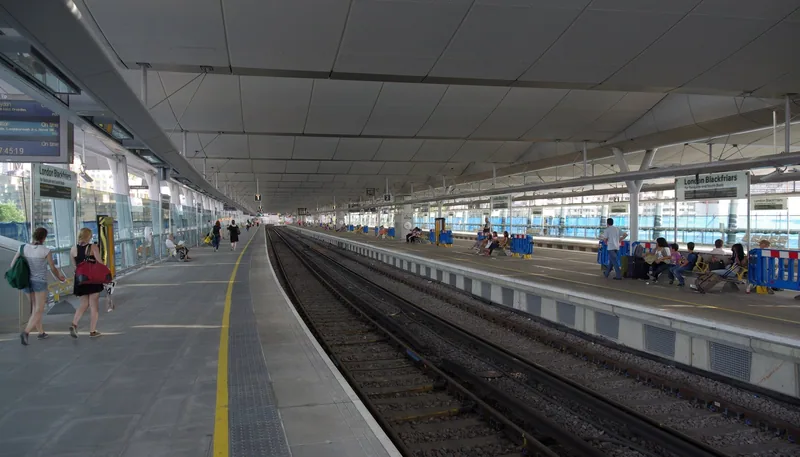
Photo: mattbuck (category) · CC BY-SA 4.0 · Wikimedia Commons · resized
The solar roof: what it is and where to see it
The roof over the platforms carries more than 4,400 photovoltaic panels covering over 6,000 square metres, which Network Rail describes as the world's largest solar bridge and the biggest solar array in London. It supplies up to half the station's own energy and cuts the station's carbon dioxide emissions by an estimated 511 tonnes a year.
Here is the frustrating part: you cannot see it from the platforms, because you are standing underneath it. The panels are on top, facing the sky, and from inside the station the roof reads as an ordinary glazed canopy. To see the array you need height and distance. The two places that work are the walkway on the east side of Waterloo Bridge, looking downstream, and the middle of the Millennium Bridge looking upstream. On a bright morning the panels read as a dark blue-grey band across the river.
The rebuild was done in halves over three years so that the station could stay open on weekdays throughout, which is why old photographs show trains running past building site hoardings on the bridge itself.
Fifty-four carved destinations, in the concourse
This is the thing worth going inside for, and almost nobody mentions it. In the northern concourse stands a wall of fifty-four sandstone blocks, each carved with the name of a place the London, Chatham and Dover Railway would sell you a ticket to from here.
They came off the façade of the original station, which opened in 1886 under the name St Paul's and was the work of J Wolfe Barry with Henri Marc Brunel, son of Isambard, and W Mills, the railway's engineer. Ashford, Gravesend and Bickley sit alongside Paris, Brussels, Vienna, Naples, Venice, Wiesbaden and Dresden, because Blackfriars sold through tickets to the Continent by cross-Channel steamer. The most distant name on the wall is St Petersburg.
The stones have moved twice. They were saved when the station was rebuilt in the 1970s and arranged as a wall of names, then designated for protection by the Railway Heritage Committee in 2009 and taken down again, block by numbered block, for the Thameslink rebuild. The lightest weighs about 45 kilograms and the heaviest up to 120. Restoration took around 1,900 hours, the lettering was regilded in 24-carat gold leaf, and the wall was unveiled in its present position on 11 June 2012.
Read the spellings, not just the names. The stones say LEIPSIC for Leipzig, FRANKFORT for Frankfurt and DARNSTADT for Darmstadt. They are Victorian English spellings of German cities, cut in stone and never corrected, which dates the wall more precisely than any plaque could.
The stumps in the river, and the crest on the south bank
Look upstream from the station or from the road bridge and you will see a line of red-painted cast-iron columns standing in the water with nothing on top of them. They are the piers of a second railway bridge, built in 1862 to 1864 by Joseph Cubitt for the London, Chatham and Dover Railway, whose superstructure was removed and whose piers were left where they stood.
Its southern abutment survives on the Southwark bank and is listed at Grade II in its own right. Historic England's entry records two things that are worth walking round to see. The abutment is faced with Portland stone taken from Charles Labelye's Westminster Bridge of 1738 to 1749, so a piece of the first Westminster Bridge is built into the south end of a railway bridge that no longer exists. And the large shields flanking the way on the Southwark side carry the railway company's crest and its title in full; they were restored around 1990.
Two more restored fragments sit at the north end: a drinking fountain on the east side of the road, and a statue of Queen Victoria at the bridge approach, both separately listed at Grade II and both cleaned up as part of the same station project.
The view, and what it costs
The platforms give you the best head-on view of the river in central London, because you are standing in the middle of it rather than on a bank. Looking upstream (west) you get Waterloo Bridge, the London Eye and, on a clear day, the Victoria Tower at the far end of the Palace of Westminster. Looking downstream (east) you get the dome of St Paul's on the left, Tate Modern's chimney on the right, and the Millennium Bridge between them.
It is not free. A pay-as-you-go single within Zone 1 is £3.10 at peak times and £3.00 off peak (September 2026), and the cheapest honest way to get the view is to make a real one-stop journey: Blackfriars to City Thameslink northbound, or Blackfriars to Elephant and Castle southbound. Both cross or leave the bridge within a couple of minutes. A paper single costs £7.00, so use contactless. Our page on how Thameslink works explains the route, and if you want river views for nothing, our round-up of the best free viewpoints in London has better options.
Worth using this station if
Use something else if
- You just want to cross the river: the road bridge is free
- You want the solar roof in a photograph: you need Waterloo Bridge, not the platform
- You need the Tube and step-free access together: the Underground station is a separate building
The Underground station, and the three years it was shut
The District and Circle line station beside the north entrance is a separate building with its own gateline. It closed for three years during the rebuild and reopened in February 2012 with a bigger ticket hall and a direct link into the main-line concourse. It is in Zone 1, has free Wi-Fi and no toilets, so use the ones in the main-line concourse. Our guide to the District and Circle lines covers where they go and which interchanges are long walks.
Half an hour here, from either end
From the north door: the destination wall inside, then out to the bridge approach for Queen Victoria and the fountain, then west along the pavement to look at the columns in the river, then up New Bridge Street for St Bride's and Fleet Street. Twenty-five minutes.
From the south door: turn right on the riverside walk for the view back at the station and the old abutment with the crest, then carry on to the OXO Tower in six or seven minutes, or left towards Tate Modern. Both directions are level and both are free.
Frequently asked questions
Does Blackfriars station really have an entrance on both sides of the Thames?
Yes. The platforms are on a railway bridge across the river, with a ticket hall at each end: Queen Victoria Street on the north bank and Blackfriars Road on the south. Network Rail describes it as the only station in London to span the Thames. We could not verify the stronger claim that it is unique in the world.
Can you walk across Blackfriars station for free?
No. Both entrances are behind ticket gates, so passing through means a valid ticket or touching in and out. The road bridge next to the station is free and open at all hours.
How many solar panels are on Blackfriars station?
More than 4,400, covering over 6,000 square metres of roof. Network Rail calls it the world's largest solar bridge and says it supplies up to half of the station's energy and saves an estimated 511 tonnes of carbon dioxide a year.
Which exit is best for Tate Modern?
The south entrance on Blackfriars Road. From there it is about six minutes east along the riverside walk. Coming out of the north entrance by mistake adds a bridge crossing and roughly ten minutes.
Is Blackfriars station step-free?
Yes, for main-line trains: National Rail rates it step-free category A, meaning step-free access to all platforms, with lifts. Staff assistance is listed as available at all hours. The neighbouring Underground station is a separate building and should be checked separately.
Sources
- National Rail - London Blackfriars (BFR) station information, accessibility and ticket office hours (checked September 2026)
- Network Rail - Connecting Britain: celebrating our bridges (Blackfriars solar figures) (checked September 2026)
- Network Rail - Six times we went green on the railway (panel count and roof area) (checked September 2026)
- Network Rail - Restored destination stones unveiled at Blackfriars station, 11 June 2012 (checked September 2026)
- Network Rail - New destination for historic Blackfriars destination wall, 24 September 2009 (checked September 2026)
- Historic England - Southern abutment to former West Blackfriars and St Paul's Rail Bridge, list entry 1376596, Grade II (Internet Archive copy, 28 January 2026) (checked September 2026)
- Historic England - The Black Friar Public House, 174 Queen Victoria Street, list entry 1285723, Grade II* (Internet Archive copy, 30 January 2026) (checked September 2026)
- Food Standards Agency - food hygiene rating for The Blackfriar, 174 Queen Victoria Street, London EC4V 4EG (checked September 2026)