
Richmond Bridge was finished in 1777 and Historic England's list entry calls it, in as many words, the oldest bridge over the Thames within the boundaries of Greater London. It is free, it carries pavements on both sides, and there are four more crossings within three miles upstream of it, three of which you can also walk.
This is the stretch where London stops behaving like a city. The banks are meadow and deer park rather than wharf, and the crossings are a five-arch Georgian bridge, a concrete bridge that was a world first, a barrage with sluice gates hung from a footbridge, and a Victorian suspension footbridge that reaches the far bank by way of an island.
Our guide to Richmond as a place to spend a day covers the town, the hill and the park, and the companion page on Twickenham and the riverside covers the houses opposite. This page is about the crossings: what each one is, which ones close, and how to string them into a walk with no traffic in it.
The crossings at a glance
- Cost
- Free, every one of them
- Nearest stations
- Richmond (District, Mildmay, South Western Railway); St Margarets; Teddington
- The loop
- About four miles, two hours with stops, flat
- Best time
- Two hours before high water, when the sluice gates go up
| Crossing (downstream order) | Date and grade | Who can use it |
|---|---|---|
| Teddington Lock footbridges | Circa 1888, Grade II | Foot only. The tidal Thames ends here |
| Richmond Lock and Footbridge | Opened 1894, Grade II* | Foot only, gated at each end |
| Richmond railway bridge | Not listed | Trains only |
| Twickenham Bridge | 1933, Grade II* | Road, pavements both sides |
| Richmond Bridge | 1777, Grade I | Road, pavements both sides, all hours |
Richmond Bridge: what the list entry actually says
The statutory description is short and tells you where to point your eyes. Historic England dates it 1777, names James Paine and Kenton Couse as its architects, and describes Portland stone, five moulded segmental arches rising gradually to the centre where the arch is widest and tallest, two land-bound semi-circular arches, moulded semi-circular cutwaters, a bracketed cornice, and balustraded parapets that turn solid above the cutwaters with iron lamp standards on top. It was widened in 1937.
Two of those details are the ones to hunt for. The arches are not the same size: they step up towards the middle, which is why the bridge looks as though it is arching its back when you see it end on from the water. And the parapet changes from open balustrade to solid stone exactly above each cutwater, so the bays of the railing tell you where the piers are without your having to look down.
The place to stand is the towpath on the Middlesex bank a couple of hundred metres upstream, which gives you the bridge with Richmond Hill behind it and the late afternoon light from behind you. Grade I puts it in the top few per cent of listed buildings in England, and it is the only crossing on this reach at that grade.
The milestone obelisk at the Richmond end has a listing of its own. So does a K6 telephone kiosk a short walk away. This is a densely designated corner of London, which is part of why nothing here looks new.
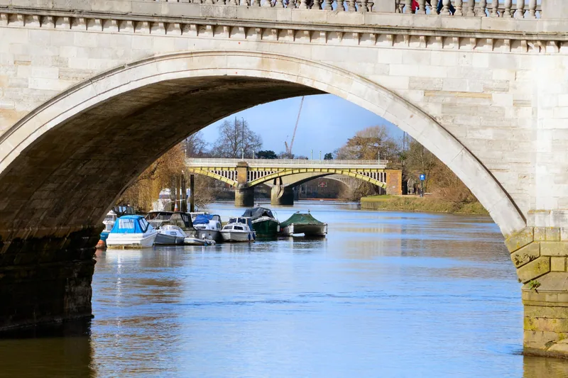
Photo: AndyScott · CC BY-SA 4.0 · Wikimedia Commons · resized
Twickenham Bridge, and the engineering first nobody wanted
Four hundred metres upstream is a wide concrete bridge that most people cross without looking at. It deserves better. The list entry describes it as 145.5 metres long and 21.3 metres wide, with five arches, three of them over the water, a central span of 31.4 metres and a pair of flanking river spans of 29.9 metres each. It was designed by Alfred Dryland and Maxwell Ayrton, built by Aubrey Watson Ltd, and completed in 1933 at a cost of £217,300.
What makes it matter is hidden in plain sight. It was the first large three-hinged concrete arch bridge built in the United Kingdom, and its three river arches have permanent hinges so that the structure can adjust itself. Ayrton refused to hide them. He marked each hinge with a decorative bronze cover plate in Art Deco style, so the ornament on the bridge is a diagram of how it works. There are more bronze plates over the expansion joints at the abutments, ornamental tiles set in horizontal seams, and paired staircase turrets with bastions that bring you up from the embankment.
The striated surface was made with specially built shuttering and then worked over with a bush hammer, which is why it has the texture of stone rather than the flat grey of a motorway pier. Locally the bridge was known as "the bridge that nobody wants", partly because the Surrey approach cut through parkland. Our guide to Art Deco London has the buildings that go with it.
Richmond Lock: a weir you walk across
Another 500 metres upstream is the strangest structure on the reach, and the one visitors miss. Richmond Lock and Weir is a half-tide barrage: three vertical steel sluice gates hung from the underside of a cast-iron footbridge, with a lock alongside and a set of boat rollers at the far end.
The Port of London Authority, which owns and operates it, publishes the numbers. Each gate weighs 32.6 tonnes, is 20 metres wide and 3.64 metres deep. For roughly two hours either side of high water the gates are winched up into the bridge structure above and boats pass straight through; for the rest of the day they are lowered and traffic uses the lock, which is 76 metres long and 8 metres wide and has a foreman on duty around the clock. The whole point of the thing is to hold the water between here and Teddington at or above half-tide level, so that the reach upstream is not a mudflat twice a day.
There is a genuine dispute about the date, so here are both figures. Historic England's amended list entry dates the structure to 1891 and credits the engineer F G M Stoney, with the lock houses by the surveyors Hunt and Steward and the ironwork by Ransome and Rapier of Ipswich; the Port of London Authority says the Duke and Duchess of York opened it officially in 1894. The older, superseded text of the same list entry says 1894 as well.
Stoney's part is the reason engineers come here. This is where he first applied the floating sluice gate and the apparatus that turns a lifted gate into the horizontal, and he went on to use the same principles at the Manchester Ship Canal in 1894 and the Aswan Dam in 1902. The overall span is 348 feet, the central 66-foot spans hold the sluices, and one of the three original lines of boat rollers survives. On the Surrey side, at the upper level, there is still a toll booth of brick and weatherboarding with a fretted canopy.
Do not count on the footbridge for the walk home. The walkways are gated at both ends and the Port of London Authority publishes no hours for them, so we cannot tell you when they lock. Treat the crossing as a daytime route. Twickenham Bridge, a few hundred metres downstream, has pavements on both sides and never shuts.
The railway bridge, and why it is the odd one out
Between Twickenham Bridge and Richmond Lock there is a third structure, a plain iron railway bridge carrying trains between Richmond and St Margarets. It is the only crossing here you cannot walk, and the only one that does not appear anywhere in the National Heritage List for England: a search of a 300-metre box around it returns nothing, while its listed neighbours stand 50 metres away on either side. District line trains use it as well as South Western Railway ones, so from the Middlesex bank you can watch a Tube train cross the Thames, which is rarer than it sounds. Our guide to the Overground and the DLR covers the Mildmay line that shares Richmond station.
Teddington Lock, and the end of the tide
Two and a half miles upstream of Richmond Bridge, the tidal Thames stops. Teddington is the boundary: below it the river is tidal and the Port of London Authority's Upper River Harbour Service patrols the water between Putney and here, and above it the river is managed as a navigation with locks all the way to Gloucestershire.
The crossing is in two parts, which confuses people who expect one bridge. The suspension footbridge of 1888, by the engineer George Pooley with Goddard and Massey of Nottingham as contractors, carries you from the Teddington bank to a small island between the river and the Lock Cut, a navigation channel dug in 1811 to 1812. A riveted girder bridge of the same date takes you from the island to the Ham bank. Both were listed together at Grade II in 2005, and both replaced a ferry. The suspension towers now sit inside polygonal concrete casings.
The tide tables here show two low waters in a row, and it is not a misprint. The Port of London Authority explains that the low-water stand at Richmond is so prolonged that its prediction programme finds two turning points, and it deliberately leaves both in the published tables rather than tidying them away.
The ferry, in one paragraph
Between Richmond Bridge and Teddington there is one more way across, and it is not a bridge. Hammerton's Ferry, a small motor launch, crosses between the Twickenham towpath near Marble Hill and the Ham bank in front of Ham House, daily from March to October and at weekends only from December to February, with no service in November. Fares, times and the warning about the ferry's old web address are on our page about Ham House and Marble Hill. One correction worth carrying with you: from the ferry, Richmond Bridge is downstream and Teddington Lock is upstream, not the other way round.
A crossings walk that works: about two hours
This is a loop, it is flat, and it needs no ferry and no ticket.
- Start on the Surrey bank at Richmond Bridge and walk downstream on the towpath, with the water on your left, past the riverside terrace and Old Deer Park. Fifteen minutes.
- At Richmond Lock, go up the steps and cross the footbridge. Stop in the middle: you are standing on the gantry the sluice gates hang from, and if the tide is near high you may see them being raised.
- Turn downstream, then left along the Middlesex bank and back upstream under the railway bridge to Twickenham Bridge. Ten minutes.
- Carry on upstream along the Middlesex towpath, past the boathouses, for about a mile to Richmond Bridge. This is the best view of it, and of the hill behind.
- Cross Richmond Bridge back into the town.
Allow two hours with stops, about four miles. The longer version keeps going upstream from Richmond Bridge to Teddington Lock, crosses, and comes back down the Surrey side: nearer eight miles and half a day. Our page on the Thames Path and London's walking routes sets both inside the long-distance route, and our running routes page has the Tamsin Trail.
What goes wrong here
Three things, and they are all about water. The highest tides put the river over the riverside road by Richmond Bridge, which catches out parked cars. The towpath between the lock and Teddington is unsurfaced in places and stays wet for days after rain, so trainers are fine in July and a mistake in February.
And boats are not reliable in a dry autumn. Low river levels and lock restrictions were delaying scheduled services on the Richmond to Hampton Court reach in September 2026, which matters if you plan to travel one way by water and walk back. Our guide to Thames river cruises has the operators and the piers, and Hampton Court by boat covers the long upstream trip.
Getting here, and how long from the centre
Richmond station is the hub: District line, the Overground's Mildmay line, and South Western Railway trains from Waterloo, all in Zone 4, with contactless and Oyster working normally. From the station it is about ten minutes on foot downhill to the bridge. For Teddington Lock, Teddington station on the Waterloo line is closest, in Zone 6, about twelve minutes down Ferry Road; for Richmond Lock from the Middlesex side, use St Margarets. If you are adding the deer, Richmond Park is a steep twenty minutes up the hill, and Kew Gardens is two stops downriver.
Frequently asked questions
Is Richmond Bridge really the oldest bridge over the Thames in London?
It is the oldest one still standing and still in use. Historic England's list entry ends with the words "now the oldest bridge over the Thames within the boundaries of Greater London", and the bridge dates from 1777. Older bridges existed downstream, but all of them have been replaced.
Can you walk across Richmond Lock footbridge?
Yes, and it is free, but the walkways are gated at each end and we could not find the opening hours published anywhere by the Port of London Authority, which owns the structure. Use it during the day and use Twickenham Bridge if you are crossing late.
What is the difference between Richmond Lock and Teddington Lock?
Richmond Lock is a half-tide barrage whose job is to hold water in the reach above it; boats pass through the raised sluice gates for about two hours either side of high tide and use the lock the rest of the time. Teddington Lock is the point where the tidal Thames ends altogether. Both have public footbridges.
How long does it take to walk between the crossings?
Richmond Bridge to Twickenham Bridge is about ten minutes on the Middlesex bank, and Twickenham Bridge to Richmond Lock another ten. Richmond Bridge to Teddington Lock is about an hour each way on the towpath. The four-mile loop over Richmond Bridge and the lock footbridge takes about two hours with stops.
Is any of this free?
All of it. Every crossing described here is free to walk, including the lock footbridge, and the towpaths on both banks are public. The only thing you pay for on this reach is the ferry and a boat trip. More free days out are in our list of free things to do in London.
Sources
- Historic England - Richmond Bridge, list entry 1180951, Grade I (Internet Archive copy, 31 December 2025) (checked September 2026)
- Historic England - Twickenham Bridge and attached railings, lamp standards and light brackets, list entry 1253011, Grade II* (Internet Archive copy, 9 January 2026) (checked September 2026)
- Historic England - Richmond Footbridge, lock and sluices, list entry 1250044, Grade II* (Internet Archive copy, 14 January 2026) (checked September 2026)
- Historic England - Teddington Footbridge, list entry 1391392, Grade II (Internet Archive copy, 4 January 2026) (checked September 2026)
- Port of London Authority - Richmond Lock and Weir (checked September 2026)
- Historic England - National Heritage List for England, open data feature service (checked September 2026)