
The Isle of Dogs is the tongue of land inside a great loop of the Thames in east London, about six kilometres downstream from Tower Bridge. It is not really an island. For a visitor it offers the best free view of Greenwich in London, an Edwardian foot tunnel under the river, a large city farm and an easy circular walk with water on three sides.
Most people arrive without meaning to, because the towers at the northern end belong to Canary Wharf. The rest of the peninsula is quite different: low brick housing, converted warehouses, playing fields and a surprising amount of open water left from the docks. Our guide to Canary Wharf covers the business district; this page is about everything south of it.
The name is old and nobody knows where it came from. Explanations involving royal kennels, Dutch dykes and dead dogs washed up on the marsh have all been offered and none is proved. What is certain is that the land was marsh, was drained, was dug out for docks between 1802 and 1868, and was then filled in again with offices after the port closed.
The Isle of Dogs in brief
- Best for
- River views, the Greenwich foot tunnel, a flat circular walk, a city farm
- Stations
- DLR: Mudchute, Crossharbour, South Quay, Island Gardens, Canary Wharf, Heron Quays
- Greenwich Foot Tunnel
- Free, open 24 hours, 370 metres, lifts and stairs at both ends
- Island Gardens
- Free public park at the southern tip, open daily
- Mudchute Park and Farm
- Free; farm daily 09:00–16:00, park dawn to dusk
- Circular walk
- About 8 km round the Thames Path and back, flat, 2–3 hours at a slow pace
- Time needed
- Half a day, or combine with Greenwich for a full one
Island Gardens and the view that Canaletto painted
At the southern tip, directly opposite Greenwich, is a small public park called Island Gardens. It is not much of a park: a strip of grass, some plane trees, a café and benches along a railing. What it has is the view.
From the railing you look straight across a few hundred metres of river at the Old Royal Naval College, with the Queen's House framed exactly between its two domed wings and the hill of Greenwich Park rising behind. Canaletto painted the composition from roughly this spot in the 1750s, and the reason it still works is that the sightline has been legally protected ever since.
This is a free view of a World Heritage Site, it faces south, and it is at its best in late afternoon when the light is behind you. It is also almost always empty compared with the Greenwich side. Our guides to the Old Royal Naval College and Greenwich Park cover what you are looking at.
Photograph Greenwich from the north bank, not the south. Standing in Greenwich you can photograph the Naval College but not the composition; standing at Island Gardens you get the whole thing, with the Observatory on the skyline. It costs nothing, needs no ticket and takes four minutes by DLR from Canary Wharf.
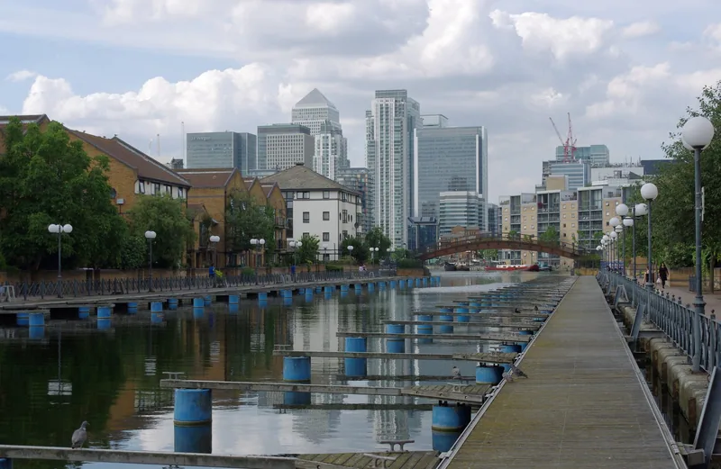
Photo: mattbuck (category) · CC BY-SA 4.0 · Wikimedia Commons · resized
The Greenwich Foot Tunnel: how it works
Beside the park stands a circular brick drum topped with a glass dome. It hides a spiral stair and a lift dropping into the Greenwich Foot Tunnel: 370 metres of passage opened in 1902 that surfaces beside the Cutty Sark on the far bank.
It is free, it is open 24 hours a day, and about 4,000 people use it every day. There are stairs and lifts at each entrance. Cyclists must dismount, without exception, for the whole length.
Inside, it is a white-tiled tube, about two and a half metres across, with a noticeable dip in the middle and a section near the south end lined with cast iron where bomb damage was repaired after the Second World War. Sound carries strangely. It takes five to seven minutes to walk.
The one thing to check before you set out is the lifts. They are old, they break, and the Royal Borough of Greenwich publishes a live status page. If a lift is out, the alternative is roughly a hundred steps, which matters if you have a pushchair, a wheelchair or luggage; our guide to accessible London explains how to plan around this kind of thing. If both lifts are out, the DLR from Island Gardens to Cutty Sark takes three minutes.
Walking round the island
The Thames Path runs round most of the peninsula, and walking the whole loop is the best way to understand the place. From Westferry Circus in the north-west, down the west side past Millwall, round the tip at Island Gardens and back up the east side through Cubitt Town is about eight kilometres, entirely flat.
The two sides are quite different. The west side looks across at Rotherhithe and Deptford and is mostly converted warehouses and new flats with the path squeezed between them and the water. The east side is more open, with wide views towards the Greenwich Peninsula, the cable car and the O2, and long stretches of river wall where nobody else is walking.
Three cautions. The path is interrupted in several places by private developments and you have to divert inland, usually for a hundred metres or so. There are very few cafés or toilets on the east side. And the river wall is exposed: on a windy winter day the east side is genuinely cold.
A shorter version is to take the DLR to Mudchute, walk south through the farm to Island Gardens, then through the tunnel to Greenwich. That is about 2.5 km and takes under an hour.
Mudchute: a hill made of mud from the docks
The large green space in the middle of the island is Mudchute Park and Farm, 32 acres of grazing land with sheep, pigs, horses, llamas and chickens, and the towers of Canary Wharf directly behind them. The farm is open every day from 09:00 to 16:00, with the animals brought in from 15:00, and the park from dawn to dusk. Entry is free.
The name is literal. When the Millwall Docks were dredged in the late nineteenth century, the silt was pumped through a chute onto this ground, and the mound it created is the highest point on the island. It was never built on, was used for allotments and anti-aircraft guns, and was saved from development by local campaigners in the 1970s.
Our guide to city farms and playgrounds covers what to expect from a London city farm, including the hygiene rules that matter with small children.
Where the ships were built
The west side of the island was a shipyard coast. Its most famous product was the SS Great Eastern, Isambard Kingdom Brunel's iron steamship, nearly 211 metres long and by far the largest vessel in the world when it was built. The river here is too narrow for a conventional launch, so the ship was built parallel to the bank and launched sideways in 1858, a process that took three months and several attempts.
Part of the slipway timbers survive at Burrell's Wharf on Westferry Road, in front of a converted Victorian ironworks, with an information panel. It is not a spectacle; it is a set of blackened baulks of timber on the foreshore, visible at low tide. But standing on the river wall and imagining a ship longer than the street being pushed sideways into the water is the single best piece of history on the island.
Further south, Cubitt Town was laid out from the 1840s by William Cubitt as housing for dock and shipyard workers. Christ Church on Manchester Road, with its tall ragstone tower, dates from that period and is the landmark on the east side.
Billingsgate, at the top of the island
At the northern edge, next to Poplar DLR station, stands Billingsgate Market, the United Kingdom's largest inland fish market. It trades Tuesday to Saturday from 04:00 to 08:30 and is open to the general public as well as to the trade.
If you are staying nearby it is worth the early alarm: a working wholesale market of this kind is a rare thing to see in a European capital, and it is about to move, because the City of London Corporation plans to relocate it to the Royal Docks. Children under 12 are not allowed on the market floor, wheeled trolleys and suitcases are banned and the floor is wet, so wear shoes with grip. Our guide to seafood and oysters in London has the full rules and the move timetable.
Getting around: the DLR and the river
The Docklands Light Railway runs the length of the island on a viaduct, with stations at South Quay, Crossharbour, Mudchute and Island Gardens before diving into a tunnel under the river to Cutty Sark and Greenwich. The trains are driverless; the front seats, where the cab would be, give a view straight down the track and are the best free ride in London for children.
Every station on the line has level access between the pavement and the carriage, and the fare is a Tube fare, counted against the same daily ceiling. How the whole network fits together is set out in our guide to the DLR and the Overground.
From the river side, Uber Boat by Thames Clippers calls at Canary Wharf pier, and the RB4 cross-river ferry runs to Rotherhithe; see the Uber Boat river bus and our guide to Wapping and Rotherhithe on the far bank. Cycling is a genuinely good option here because the island is flat and the roads are quiet at weekends; see cycling in London.
Buy nothing for the walk on the east side. There are shops and cafés at Crossharbour and around Canary Wharf, and almost nothing between Island Gardens and Blackwall on the eastern river wall. Fill a water bottle and use the toilets before you leave the farm or the park, because the next reliable ones are a couple of kilometres away.
What it is like to stay, and when to come
The island has a growing number of hotels and serviced apartments, most of them at the northern end near the offices. Prices drop at weekends when business travellers leave, and the Jubilee and Elizabeth lines put central London within about fifteen minutes.
The trade-off is quiet. South of the towers there is very little going on in the evening: a handful of pubs, a few restaurants along Westferry Road and Manchester Road, and not much else. It suits people who want to sleep, walk and travel in, rather than people who want to walk home from dinner.
The best time to visit is a clear afternoon, ideally in autumn or spring when the light is low and the river reflects. Summer weekends are pleasant but the farm is busier; winter on the east side is bleak in a way some people love and others do not. One thing to factor in if you cross to the far bank: after 2 November 2026 the Royal Observatory shuts for rebuilding, and its Meridian Courtyard is not expected back until the summer of 2027. Our guide to the Royal Observatory and Cutty Sark has the details.
Frequently asked questions
Is the Greenwich Foot Tunnel free and always open?
Yes to both. It is free to use and open 24 hours a day, with stairs and lifts at each end. The lifts are old and sometimes out of service, and the Royal Borough of Greenwich publishes a live status page, so check it if you have a pushchair, luggage or mobility needs.
Can I cycle through the Greenwich Foot Tunnel?
You may take a bicycle through, but you must dismount and push it. Visit Greenwich states that cyclists must dismount "without exception". The tunnel is narrow and busy at commuting times, so it is not a shortcut worth arguing about.
Is the Isle of Dogs actually an island?
No. It is a peninsula inside a tight meander of the Thames, joined to Poplar at the northern end. The docks cut across it made it feel like one, and parts of it were effectively separated by water and swing bridges, but there has always been dry land at the top.
What is the best view of Greenwich from the north bank?
Island Gardens, at the southern tip of the Isle of Dogs, a two-minute walk from Island Gardens DLR station. It gives the view of the Old Royal Naval College with the Queen's House framed between the domes and the Observatory on the hill behind, and it is free.
How long does it take to walk round the Isle of Dogs?
The full loop on the Thames Path is about eight kilometres and takes two to three hours at a slow pace, with diversions inland where private developments interrupt the route. A shorter version, from Mudchute through the farm to Island Gardens, takes under an hour.
Sources
- Visit Greenwich - Greenwich Foot Tunnel: length, opening and cycling rules (checked September 2026)
- Royal Borough of Greenwich - live foot tunnel and lift status (checked September 2026)
- Mudchute Park and Farm - opening times (checked September 2026)
- City of London Corporation - Billingsgate Market trading hours and stations (checked September 2026)
- Transport for London - the Docklands Light Railway (checked September 2026)
- Uber Boat by Thames Clippers - route map (checked September 2026)