
Marble Arch is a white marble triumphal arch standing on a traffic island at the point where Oxford Street, Park Lane, Edgware Road and Bayswater Road meet. It is free, it is always open, and it takes about ten minutes to look at. The reason to stop is not the arch but the ground: a stone set into the paving marks the site of the Tyburn gallows, where London hanged people for nearly six hundred years.
The arch was not built here and it was not built for this. John Nash designed it in 1827 as the state entrance to the courtyard of Buckingham Palace, and in 1851, on the initiative of Decimus Burton - one of Nash's former pupils - it was taken down and re-erected at the north-east corner of Hyde Park. When Park Lane was widened in the early 1960s the road swallowed the ground around it, and the Grade I listed arch was left marooned on an island with traffic on every side.
Most visitors pass it on the way from Oxford Street to Hyde Park, both of which have their own guides here. This page is about the ten minutes in between: what to look at on the island, what the stone in the ground means, and what Park Lane is actually for.
The island at a glance
- Where
- Marble Arch, London W1C 1LU
- Cost
- Free. You cannot go inside the arch
- Open
- The site opens every day from 8am; closing time varies with the season
- Nearest station
- Marble Arch (Central line), directly beneath the junction
- How long
- Ten minutes for the arch and the Tyburn stone; forty if you walk down Park Lane
- Access
- Westminster City Council describes the site as wheelchair accessible; dogs are welcome
- Nearby
- Speakers' Corner is two minutes inside the park; Hyde Park's pedestrian gates open 5am to midnight
Reading the island: what is actually there
Westminster City Council looks after the space rather than the Royal Parks, and it is laid out as two islands. The western one is a lawn, set slightly lower and shielded along its southern side by a planted bank, which is why the grass appears to sweep up into the earthworks. The eastern one is a paved plaza with the arch at one end and a line of flagpoles down each side, and York stone paths lead off it towards Edgware Road and Bayswater Road.
There are raised seats, and in summer a soft-surfaced area to sit on. The council also points to the other thing people photograph here: a bronze horse's head about twenty-seven feet high, by the sculptor Nic Fiddian-Green, which sits near the arch and does more for the space than the arch does.
You cannot go into the arch. There are rooms inside it, and they have been put to various official uses over the years, but they are not open to the public and there is no ticket, no tour and no interior to see. Anyone expecting the Wellington Arch, which you can climb for a view, should read our guide to Apsley House and Wellington Arch instead: that is the arch at the other end of Park Lane, and it is the one with the viewing platform.
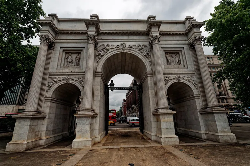
Photo: Txllxt TxllxT · CC BY-SA 4.0 · Wikimedia Commons · resized
The Tyburn stone, and what stood here
Set into the paving at the junction is a round stone inset marking the site of the Tyburn gallows. It is easy to walk over without noticing, and it is the most significant thing on the island.
Tyburn was the King's Gallows for London and Middlesex, deliberately placed outside the boundary of the City. The first recorded execution here was in 1196, when William FitzOsbert was dragged behind a horse through the city and hanged for sedition; the last was in 1783, after which hangings moved to Newgate, whose site is now occupied by the Old Bailey. In between, the gallows went by a series of names - the Elms, the Tyburn Tree, the Triple Tree - and in Elizabeth I's reign a triangular gallows was built that could hang several people at once.
How many died here is not settled. The Royal Parks states flatly that more than 50,000 people were executed at Tyburn; Tyburn Convent, which keeps the memory of the Catholic martyrs who died here, writes more cautiously that "some say" over fifty thousand. Take the figure as an order of magnitude rather than a count. Among those hanged were the highwayman Claude Duval, the escapologist Jack Sheppard and the thief-taker Jonathan Wild, and 105 Roman Catholic martyrs of the Reformation. Convicted traitors were hanged, then disembowelled and quartered, with the quarters displayed in public places.
The final speech at Tyburn became the right to speak in the park. Everyone condemned here was allowed to address the crowd, and some used it to protest their innocence or attack the authorities; spectators bought seats on wooden stands to watch. When an Act of Parliament in 1872 set aside the north-east corner of Hyde Park for public speaking, it was formalising a habit that had grown up around the scaffold. Speakers' Corner is a hundred metres from the stone, and our Hyde Park guide covers it.
Tyburn Convent, and why the crypt is shut
On Bayswater Road, a short walk from the stone, a community of Benedictine nuns keeps the Shrine of the Martyrs in a crypt beneath their house, with relics of those executed at Tyburn, a small replica of the gallows and two panels of stained glass by Margaret Rope showing scenes from the martyrs' lives. In normal times a sister gives guided tours, with groups asked to make an appointment first.
It is closed. The convent states that the Crypt of the Martyrs has been closed to tours since 22 June 2026 because of renovation work in the sanctuary, and that it expects the crypt to stay closed to tours until mid-2027. The church above remains a working place of prayer; the crypt is the part visitors come for, and it is not available. If you are planning around it, telephone before you travel rather than trusting a listing.
Park Lane: what happened to it, and what is left
Park Lane was a narrow road along the eastern boundary of Hyde Park, lined with some of the grandest private houses in London. In the early 1960s it was widened into the dual carriageway it is now, taking a strip of the park with it, and the strip that was left became the long central island you see between the two carriageways.
What that means for a walker is straightforward and slightly disappointing. The hotels are on the eastern side and the park is on the western side, and between them are several lanes of fast traffic and a central reservation you reach by subway or crossing. It is not a street for strolling. Our guide to Mayfair and St James's covers the streets behind it, which are the ones worth walking, and London's grand hotels deals with the buildings.
The better way to see Park Lane is from the top of a bus. Route 148 runs its whole length with the hotels on one side and the park on the other, then swings west at Marble Arch along the entire northern edge of Hyde Park; our guide to bus routes worth riding for the view sets it against the other candidates. At £1.75 a journey in September 2026 - rising to £1.85 on 1 November 2026 - it is the cheapest sightseeing in London.
Walking it: a twenty-minute route that makes sense
- Come up from Marble Arch station (Central line) and follow the signs for Hyde Park rather than Oxford Street, which puts you on the island rather than across the road from it.
- Find the Tyburn stone at the junction end, then look back at the arch from the plaza, which is the only angle where it reads as a building rather than a roundabout ornament.
- Cross into Hyde Park at Speakers' Corner. On a Sunday morning there will be people speaking; on a Tuesday afternoon there will not.
- Walk south inside the park, parallel to Park Lane, rather than along the pavement. It is quieter, it is the same distance, and it comes out at Hyde Park Corner in about twenty-five minutes.
Doing it in reverse, from Hyde Park Corner, works equally well and finishes you at the top of Oxford Street with the shops in front of you.
The Oxford Street works, and what they will change here
Oxford Street begins at Marble Arch. The traffic-free scheme for the street covers the section from Orchard Street to Great Portland Street, which starts a couple of minutes east of the arch, and the western section was being prepared for that change with a target of late October 2026. Marble Arch itself is a junction of four major roads and is not part of the scheme, so do not expect the island to become any calmer. Check our Oxford Street guide for the current state of the works before you plan a shopping day around them.
What is within five minutes
North of the junction, Edgware Road starts immediately and its Lebanese restaurants and bakeries begin within a hundred metres - the most useful thing near the arch if you are hungry, and far better value than anything on Park Lane. East along Oxford Street, Selfridges is a five-minute walk. North-east, in a square behind the shops, the Wallace Collection is free and is one of the quietest good museums in London.
Marylebone is ten minutes north and takes its name from a church built beside the Tyburn, the small river that gave the gallows their name and still runs underground. The river and the gallows were not in the same place, which is a common confusion: the stream ran east of here, and the scaffold stood at the road junction.
Two other London monuments moved a long way to reach the spot they now occupy: the obelisk in our guide to Cleopatra's Needle and the Victoria Embankment, and - a different kind of Victorian statement altogether - the Albert Memorial on the other side of the park. If you arrive in London by coach from Luton, several services stop at Marble Arch, as our guide to Luton to central London explains.
Is it worth going out of your way for?
No, and we would not send anyone across London for it. As something to notice on a walk you were making anyway, it is worth every one of its ten minutes: a palace gateway in the wrong place, a stone in the pavement recording six centuries of public killing, and a corner of a park where people still stand up and shout because of it. That is a lot for a traffic island.
Frequently asked questions
Can you go inside Marble Arch?
No. The arch has rooms within it, but they are not open to the public and there is no tour or ticket. The arch is free to walk up to and photograph at any time the site is open, which is from 8am daily, with closing times varying through the year. For an arch you can go up, Wellington Arch at Hyde Park Corner has a viewing platform.
Where exactly was the Tyburn gallows?
At the road junction beside Marble Arch, where Bayswater Road, Park Lane, Oxford Street and Edgware Road meet. A round stone is set into the paving to mark the site. The gallows stood there from 1196 until 1783, after which executions moved to Newgate in the City.
Why was Marble Arch moved?
It was built in 1827 as the state entrance to the courtyard of Buckingham Palace and re-erected at the corner of Hyde Park in 1851, on the initiative of the architect Decimus Burton. The widening of Park Lane in the early 1960s then cut it off from the park and left it on a traffic island.
Is Speakers' Corner still active?
Yes, chiefly on Sunday mornings, when speakers and crowds gather at the north-east corner of Hyde Park. An Act of Parliament in 1872 set the area aside for public speaking, and anyone may turn up unannounced to speak on any subject provided the police consider the speech lawful. Midweek there is usually nothing happening.
Is Park Lane worth walking down?
Not on the pavement. It is a multi-lane road and the interesting buildings are on one side with the park on the other. Walk inside Hyde Park parallel to it instead, which takes about the same time from Marble Arch to Hyde Park Corner, or ride the 148 bus from the upper deck.
Sources
- Westminster City Council - Marble Arch (history, layout, opening and access) (checked September 2026)
- The Royal Parks - Speakers' Corner and the history of the Tyburn gallows (checked September 2026)
- The Royal Parks - Hyde Park (pedestrian gate opening times) (checked September 2026)
- Tyburn Convent - Tyburn Tree (dates, names, those executed, the stone inset) (checked September 2026)
- Tyburn Convent - Martyrs' Shrine and crypt tours (closure from 22 June 2026) (checked September 2026)