
The Hertford Union Canal is two kilometres, a mile and a quarter, of dead-straight water along the southern edge of Victoria Park, with three locks on it and a pub at each end. It is free, it has a towpath the whole way, and it takes about half an hour to walk. It was a commercial failure for most of its working life, which is why it is now the quietest towpath in east London.
Boats use it as a short cut, joining the Regent's Canal to the River Lee without going out onto the Thames. Walkers use it as the link between Mile End and the Olympic Park. Almost nobody uses it as a destination, and that is the argument for going.
Our guide to Hackney Wick and Fish Island covers the eastern end and the warehouses around it, and Victoria Park covers the park the canal runs beside, including which gates open onto the towpath. This page is about the canal itself: the dates, the locks, the bridges and what goes wrong.
The Hertford Union Canal at a glance
- Length
- 2 km, a mile and a quarter, with three locks
- Other names
- Duckett's Canal, or Duckett's Cut, after Sir George Duckett, who promoted it
- Dates
- Act of Parliament 1824; opened, in the Canal & River Trust's word, unceremoniously in the spring of 1830
- West end
- Hertford Union Junction with the Regent's Canal, E3 5SH. Bethnal Green (Central line) or Cambridge Heath (Overground), about 15 minutes' walk
- East end
- Carpenters Road Bridge, E15 2HG, at the Olympic Park. Hackney Wick (Overground) is closer to the last lock
- Price
- Free, no gates, open at all hours
- Walking time
- About 30 minutes end to end; an hour if you stop at the locks
A canal that nobody wanted
The Hertford Union is the only London canal whose own owner describes its opening as unceremonious. The Act authorising it passed in 1824 and the water opened in the spring of 1830, and the Canal & River Trust's history of it is a short story of disappointment: never a great commercial success, unnavigable for several years in the middle of the nineteenth century, advertised for sale in 1851 with real difficulty in finding anyone willing to invest in it.
The proprietors of the Regent's Canal eventually bought it, and from 1857 it was a branch of the Regent's rather than a canal in its own right. In 1929 it passed to the Grand Union Canal Company. It has been somebody else's side-channel ever since, which is why it still has three intact locks, two listed bridges and no crowds.
The name belongs to Sir George Duckett, who promoted it. His father, also George, had promoted the Stort Navigation and had changed the family name from Jackson on being made a baronet — which is roughly why a canal in Bow carries the name of a Hertfordshire town it never reached.
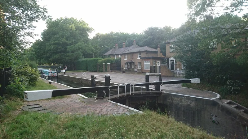
Photo: Paul the Archivist · CC BY-SA 4.0 · Wikimedia Commons · resized
The junction, and the bridge you have to walk through
The west end is the harder end to find, and the trick is a listed bridge. At Hertford Union Junction the Regent's Canal widens out like a lake, bordered by willows, and the Stop Lock Bridge carries the Regent's towpath up and over the mouth of the Hertford Union. It is listed at Grade II, entered on the national list on 3 December 2002.
To get onto the Hertford Union towpath you go through a gap in that bridge's railings and take the slope down. If you miss the gap you will walk straight past the canal on the higher path, which is what most people do.
Just beyond Old Ford Road Bridge, on the Regent's Canal side, is Old Ford Lock, with a Grade II listed lock cottage — listed in October 1990 — and a stable block that once housed and rested the horses that pulled the boats. Opposite, on the far bank, is Bow Wharf.
Bow Wharf and the 1896 sawmill chimney
Bow Wharf, on Wennington Road, E3 5SN, is a converted industrial yard at the western end, inside a conservation area. The Canal & River Trust records that a former paint factory here now holds a gym, a distillery, a bar and a restaurant, and that the brick chimney and the lean-to beside it date from an 1896 steam sawmill. That chimney is the one piece of visible industrial archaeology at this end, and it has nothing to do with the paint works everyone assumes it belongs to.
The pub here is The Crown, by Victoria Park's western gate, which is listed at Grade II in its own right — as The Crown Hotel — from 27 September 1973. It holds a food hygiene rating of 5 from an inspection on 6 November 2024. It is the obvious start or finish for the walk, and it is five minutes from the junction.
There are no public toilets on the canal. The Trust directs visitors at this end to the ones in Victoria Park.
The three locks, named
This is the part no other page carries, and it is the reason to read this one. The Hertford Union has three locks and they are called, from west to east, Top Lock, Middle Lock and Bottom Lock. Two of them and one lock cottage are listed.
| Lock | What is there | Listed? |
|---|---|---|
| Top Lock | A path beside the lock leads up into Victoria Park through another gate. The towpath then passes under Parnell Road Bridge | Yes, Grade II, October 1990. One of the lock cottages beside it is separately listed at Grade II, same date |
| Middle Lock | The canal entrance to a garden centre sits right beside it, and the towpath dives under Wick Lane Bridge immediately afterwards. The park wall above the towpath between Top and Middle Lock is covered in graffiti | Not listed |
| Bottom Lock | Just past the A12 road bridge. Regularly used as a film and photography location because of the large graffiti mural on it. Fish Island Village is opposite, below the lock | Not listed |
The three locks drop the canal to the level of the Lee Navigation, which is why so many fit into a mile and a quarter. On a weekday you may have all three to yourself.
Three Colts Bridge is listed twice over
The best single object on the canal is a small cast-iron bridge, known both as Gunmakers Lane Bridge and as Three Colts Bridge, and it carries two separate designations: listed at Grade II* in October 1990 and also a scheduled ancient monument.
Historic England's description is worth having before you stand on it. It is an accommodation bridge of 1830 with twentieth-century alterations, contemporary with the opening of the canal. The deck is a slightly cambered cast-iron girder. The east side has an open geometric iron parapet railing, protected by iron mesh screens; the west side has the mesh screens only, with no decorative railing behind them. The abutments and wing walls are brick with a brick band, stone quoins and stone copings, and the road surface across it is concrete and asphalt.
Its name comes from a gun factory that stood nearby, and the housing opposite is called Gunmakers Wharf. A gate here leads directly into Victoria Park, with a café a short walk inside it — useful, because there is nothing to eat on the towpath.
Look at the two sides of Three Colts Bridge and you can see what was lost. The listing records a decorative geometric parapet on the east side and plain mesh screens on the west. Standing on the deck, the difference is obvious once you know to look for it, and it is the clearest surviving evidence of what an 1830 accommodation bridge looked like before the twentieth century got at it.
The park side, the wall side
For most of its length the canal has Victoria Park on the north bank and industry, or what used to be industry, on the south. From Skew Bridge eastwards the towpath is fringed by the park's southern edge, and the ground slopes down towards the water, which is why people sit on the grass above the towpath in summer rather than on the towpath itself.
The Canal & River Trust gives Victoria Park as over 86 hectares, opened in 1845, and one of the most visited green spaces in the city with more than nine million visitors a year. Almost none of them is on the towpath. The park absorbs them.
South of the water the names tell you what was here. Fish Island Village, below Bottom Lock, occupies an area that was full of factories on streets named after fish — Bream Street among them — which is where Fish Island got its name.
The A12 tunnel, and what to expect in February
The one stretch people remember is the A12. The road bridge is wide enough that walking under it feels like a short tunnel, and it is covered in graffiti and painted work, which is either the best or the worst part of the canal depending on your taste. It is also, on a wet February afternoon, dark and loud.
February is worth planning for rather than avoiding. The canal is at its most legible in winter: the park's trees are bare so the sightlines open, and the lock gates and paddles are visible instead of buried in leaf. It is also when the towpath edges are muddiest and when the unlit stretches matter, because dusk falls at about four.
In summer the reverse applies: the park side is shaded and green and the towpath fills with cyclists both ways. Our page on cycling in London covers the etiquette, which matters here because the towpath narrows at every bridge even though the canal is straight.
The east end, and the pubs that are actually there
The canal ends where it meets the Lee Navigation, and the view opens onto the London Stadium and the twisted red steel of the ArcelorMittal Orbit behind it. The Trust's walk finishes at Carpenters Road Bridge, E15 2HG, where there are canalside bars, cafés and floating barges and grass to sit on.
Turn left instead, into Hackney Wick, and the yards behind White Post Lane hold the drinking. Three places there hold a food hygiene rating of 5: the Lord Napier, inspected on 15 May 2025; Howling Hops, a brewery tap, inspected on 12 November 2025; and Crate Bar and Pizzeria in the White Building, inspected on 25 November 2024. Between them and The Crown at the far end, the promise of a good pub at each end of this canal holds up.
For the breweries specifically, our guide to craft beer and brewery taprooms explains how the Hackney Wick yards work and when they open, which is not every day. From Carpenters Road Bridge it is ten minutes into the Queen Elizabeth Olympic Park, or twenty minutes north-west along the Regent's Canal to London Fields and Broadway Market.
The 90-minute version of this walk starts at Bethnal Green and ends at Hackney Wick. Walk up to the Regent's Canal, east to the junction, through the gap in the Stop Lock Bridge railings, then the full mile and a quarter past the three locks to the Lee Navigation, and out at Hackney Wick station. It is flat, it is under three miles including the approach, and there is a station at each end. Going the other way means finishing with the hardest end to find.
Access and surfaces
The towpath runs the whole length and the canal is flat, but the approaches are not: the western entrance is a slope down from the Stop Lock Bridge, and access from the street elsewhere is by steps in some places and ramps in others. The Canal & River Trust publishes a towpath accessibility map, and for a wheelchair or a heavy pushchair that is the thing to check first.
The gates from Victoria Park onto the towpath are the easiest way in and out at several points along the route, which is the practical answer if a stretch turns out to be blocked or under repair. Our guide to walking in London makes the wider point that the towpath network is often the flattest route across east London, and the Limehouse Cut continues the same idea south from the Lee Navigation to the Thames.
Nothing on this page costs anything, which puts the whole walk on our list of free things to do in London.
Frequently asked questions
How long is the Hertford Union Canal?
Two kilometres, or a mile and a quarter, from its junction with the Regent's Canal at the western corner of Victoria Park to the Lee Navigation at Hackney Wick. Walking it takes about half an hour without stopping, or an hour if you look at the three locks properly.
What are the three locks on the Hertford Union called?
Top Lock, Middle Lock and Bottom Lock, running west to east. Top Lock is listed at Grade II, as is one of the lock cottages beside it, both since October 1990. Bottom Lock, just east of the A12 bridge, is the one with the large graffiti mural that gets used for film and photo shoots.
Why is it called Duckett's Canal?
After Sir George Duckett, who promoted it. The Act of Parliament authorising the canal passed in 1824 and it opened in the spring of 1830. His father, also George, had promoted the Stort Navigation and had changed the family name from Jackson after being made a baronet.
Is there a pub at each end of the Hertford Union Canal?
Yes. At the western end, by Victoria Park's gate near the junction, The Crown is listed at Grade II and holds a food hygiene rating of 5 from November 2024. At the eastern end, in Hackney Wick, the Lord Napier, Howling Hops and Crate Bar and Pizzeria all hold a rating of 5.
How do you get onto the Hertford Union towpath from the Regent's Canal?
Through a gap in the railings of the Stop Lock Bridge at the junction, then down a slope. The bridge carries the Regent's Canal towpath over the mouth of the Hertford Union, so if you stay on the higher path you will walk past the canal entirely.
Sources
- Canal & River Trust – Hertford Union Canal: length, the 1824 Act, the 1830 opening, the commercial history and the Duckett family (checked September 2026)
- Canal & River Trust – London canal walk to Olympic Park: the Stop Lock Bridge, Bow Wharf and the 1896 sawmill, the three locks, Three Colts Bridge and Fish Island (checked September 2026)
- Canal & River Trust – Old Ford Lock and Bow Wharf: address, toilets and nearest stations (checked September 2026)
- Historic England – list entry 1065740, Three Colts Bridge: Grade II*, scheduled monument, full description (Internet Archive copy) (checked September 2026)
- Historic England – National Heritage List for England open data (Stop Lock Bridge 1096025; Top Lock 1357546; Lock Cottages at Top Lock 1065741; Lock Cottage at Old Ford 1357545; The Crown Hotel 1357862) (checked September 2026)
- Canal & River Trust – towpath accessibility map (checked September 2026)
- Food Standards Agency – food hygiene rating register (The Crown, E3 5SN, rated 5 on 6 November 2024; Lord Napier, E9 5EN, rated 5 on 15 May 2025; Howling Hops, Queens Yard E9 5EN, rated 5 on 12 November 2025; Crate Bar & Pizzeria, The White Building, Queens Yard E9 5EN, rated 5 on 25 November 2024) (checked September 2026)