
The Limehouse Cut is the oldest canal in London: two miles of dead-straight water from Limehouse Basin, beside the Thames, to the River Lee at Bromley-by-Bow. The Canal & River Trust, which owns it, calls it exactly that. It is free to walk, the towpath runs the whole length, part of it floats, and on a weekday morning you will meet more cormorants than people.
It was built for a single, entirely practical reason. To get from the River Lee down to the Thames by the natural route, a barge had to follow Bow Creek, a winding tidal channel badly suited to inland boats, and then wait for the tide before rounding the long southward loop of the Thames about the Isle of Dogs. The River Lea Act of 1766 authorised a straight cut instead, from the Lee Navigation at Bromley-by-Bow to the Thames at Limehouse.
The result is a canal with no bends at all, which is what makes walking it feel unlike any other London towpath: you can see a quarter of a mile ahead, and the buildings step away from the water in a long perspective.
The Limehouse Cut at a glance
- Length
- Two miles, Limehouse Basin to the Lee Navigation at Bromley-by-Bow
- Price
- Free, at all hours. No gates
- Owner
- Canal & River Trust (charity number 1146792)
- Opened
- Authorised by the River Lea Act 1766. The Trust's own pages give both "dating back to 1766" and "opened in 1768" — see below
- South end
- Limehouse Basin. Limehouse station (DLR and c2c), E14 7JY
- North end
- Bow Locks and Three Mills. Bromley-by-Bow (District and Hammersmith & City) or Bow Church DLR
- Walking it
- Allow 45 minutes to an hour one way at a steady pace
1766 or 1768: the Trust contradicts itself
Two pages on the Canal & River Trust's own website give different dates. The page for the canal says the Cut dates back to 1766, which is the year of the enabling Act. The Trust's walk notes for Limehouse Basin say it opened in 1768.
We are printing both rather than choosing. The Act is 1766 and the water was in use by the late 1760s; if a date matters to you, treat 1766 as the authorisation and the opening as a year or two later. What is not in dispute, because the Trust states it twice in different places, is that this is London's oldest canal — older than the Regent's Canal by half a century.
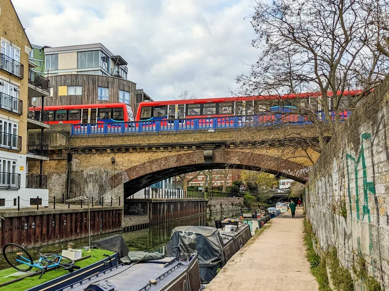
Photo: The wub · CC BY-SA 4.0 · Wikimedia Commons · resized
The end that used to be somewhere else
The Cut originally ran straight into the Thames. Its exit lock was replaced in 1968 by a short length of new canal joining the Cut to the Regent's Canal Dock, which is now Limehouse Basin, and that is the route boats take today.
The old entrance is still there, along Narrow Street, and its walls are listed at Grade II in their own right, entered on the national list on 27 September 1973 as the Limehouse Cut Entrance Walls. It takes five minutes to walk round and look at them, and almost nobody does. That is the single best small discovery on this canal: a hole in the river wall that was the mouth of London's oldest canal for two centuries.
Do the basin before the canal, not after. Everything with a date on it is at the south end: the entrance walls, the ship lock, the accumulator tower, Hawksmoor's church. Walk the two straight miles north afterwards, when you have the story in your head, and finish at Three Mills. Doing it the other way round means arriving at the interesting end with tired legs.
Limehouse Basin, in numbers
The basin is where the Cut, the Regent's Canal and the Thames meet, and it was opened in 1820 as Regent's Canal Dock. The Trust records 1,500 ships and 15,336 barges entering the dock in 1865 alone, which is the figure that explains the size of the mooring bollards you walk past. The name Limehouse comes from Les Lymhoost, the fourteenth-century lime kilns on the river bank.
Today it is a ninety-berth marina surrounded by flats. Four things in it are worth stopping for.
| What | Detail |
|---|---|
| Limehouse Ship Lock | 100 feet by 30 feet, built in 1989 inside the chamber of the former ship lock, which was almost three times as long and twice as wide. The original gate recesses are still visible, which is how you grasp the old lock's size |
| The swing bridge | Carries Narrow Street over the Thames entrance and swings open for tall ships going in or out |
| The Accumulator Tower and chimney | Grade II listed, built in 1869 to regulate the hydraulic pressure that powered the dock's cranes, locks, capstans and swing bridges. The Trust says it can usually be visited during the Open House Festival in September |
| The railway viaduct | Grade II listed, the brick arches that now carry the DLR, listed in May 1980 as far as Three Colt Street. You walk under them coming out of Limehouse station |
The basin's wildlife list is longer than the marina suggests: swans nesting on floating platforms, geese, coot, moorhen and ducks, with cormorants, gulls and grey herons coming in to fish for carp and bream. For a September visit, the buildings that open for one weekend only are covered in our guide to the Open House Festival.
The pub at the bottom, and the church above it
Narrow Street, along the river from the basin, holds the oldest thing here. The Grapes is listed at Grade II, entered on the national list in September 1973, and the Canal & River Trust records the building as being of 1583 and one of the oldest pubs in London, with Charles Dickens drinking there and writing about it in Our Mutual Friend. It is co-owned by the actor Sir Ian McKellen. It holds a food hygiene rating of 5 from an inspection on 8 July 2025.
Three minutes inland, the church of St Anne Limehouse is Nicholas Hawksmoor's, and it is listed at Grade I — the top category — from as far back as December 1950. In its churchyard stands a stone pyramid, listed separately at Grade II in 1997, about twenty-five metres north-west of the church, which nobody has ever satisfactorily explained. Our page on the Wapping riverside pubs covers the walk west along the Thames from here.
Walking the straight two miles
The towpath runs the whole length of the Cut. Part of it is a floating towpath — a pontoon walkway built out over the water where the buildings came right down to the canal edge and there was no bank to walk on. It is the most unusual stretch of towpath in London and it is the reason the route is continuous at all.
North of the basin the canal passes Ropemakers Field, a park made on derelict ground where rope for ships' anchors, rigging and mining was spun for centuries. Samuel Pepys came to see it in 1664 and Tsar Alexander II of Russia in 1871. Underneath the park runs the Limehouse Link tunnel, which the Trust describes as reputedly the most expensive road ever built in Britain.
From there it is a straight line north-east, with the DLR crossing overhead, new flats on both sides for most of the way, and a scatter of older industrial buildings surviving between them. The Trust is honest about the canal's history here, noting that it once had an unsavoury reputation and that redevelopment has changed both the water and the area considerably. What that means for a walker in 2026 is a clean, well-used towpath with houseboats on it.
The north end: Bow Locks and Three Mills
The Cut meets the Lee Navigation at Bromley-by-Bow, and this is where it earns the journey. Within a few hundred metres of the junction:
- The House Mill, a tide mill listed at Grade I since March 1955. A tidal mill, on a river, inside London.
- The Clock Mill beside it, Grade II from the same date, with the offices opposite it and even the paved roadway between the two mills separately listed.
- Twelvetrees Crescent Bridge, Grade II, listed in June 1996.
- Gasholder No 2 of the former Bromley-by-Bow gasworks, Grade II since October 1984, with a listed statue of Sir Corbet Woodall, a gas engineer, nearby.
From the junction you can turn north up the Lee Navigation towards the Queen Elizabeth Olympic Park, or west along the Hertford Union Canal to Victoria Park, which is the other short cut in this network and the quieter of the two. Our guide to Bow and Mile End covers the streets on either side, and Tower Hamlets Cemetery Park, a Victorian burial ground now run as a woodland nature reserve, is fifteen minutes west of the Cut's midpoint.
The best single-ticket day here is a triangle. Limehouse station to Bow Locks along the Cut, west along the Hertford Union past Victoria Park, then south on the Regent's Canal through Mile End back to Limehouse. That is roughly six miles of continuous towpath, all of it flat, with a station within ten minutes at every corner if you want to stop early.
Access, surfaces and what to check first
This is a working canal towpath rather than a park path, and the Canal & River Trust publishes an accessibility map for exactly this reason: conditions change between bridges, and access from the street is by steps in some places and by ramps in others. Check that map for the sections you intend to walk rather than trusting a general description, including ours.
The floating section is a boarded pontoon with railings. There are no toilets anywhere on the canal, and no drinking water. The nearest facilities at the south end are in the shops and cafés around Limehouse station; at the north end, in the retail park at Bromley-by-Bow.
Cyclists use the towpath too, a good many of them at commuting speed, and long stretches of it are unlit. Our page on cycling in London explains the towpath etiquette, and it applies here more than most places because the straightness encourages speed.
On the water itself, a Canal & River Trust small-craft licence is needed to paddle, and our guide to kayaking and paddleboarding in London sets out what it costs and where the rules change between the canal and the tidal river. Walking the Cut costs nothing at all, which puts it on our list of free things to do in London.
Frequently asked questions
Is the Limehouse Cut really London's oldest canal?
The Canal & River Trust, which owns it, says so on two separate pages. It was authorised by the River Lea Act of 1766, which puts it roughly half a century before the Regent's Canal. The Trust's own dates for the opening differ between pages, giving 1766 on one and 1768 on another.
How long does it take to walk the Limehouse Cut?
Allow 45 minutes to an hour for the two miles one way, at a steady pace and without stopping. Add another hour if you want to look at Limehouse Basin properly at one end and Three Mills at the other, which is what makes it a half-day rather than a walk.
Where does the Limehouse Cut start and finish?
It runs between Limehouse Basin, beside the Thames, and the Lee Navigation at Bromley-by-Bow. Limehouse station, on the DLR and c2c, is at the southern end; Bromley-by-Bow on the District and Hammersmith & City lines, and Bow Church on the DLR, serve the northern end.
What is the floating towpath?
A pontoon walkway built out over the water on the stretch where buildings come down to the canal edge and there is no bank to walk along. It is what makes the towpath continuous for the full two miles, and the Canal & River Trust describes it as part of the waterside walk.
Is the Limehouse Cut worth walking?
Yes, if you like industrial archaeology or want a long flat walk with almost no tourists on it. No, if you are looking for pretty countryside canal: this is a straight urban channel between new flats for much of its length. The two ends carry nearly all of the interest.
Sources
- Canal & River Trust – Limehouse Cut: London's oldest canal, the River Lea Act 1766, the floating towpath and the 1968 change of entrance (checked September 2026)
- Canal & River Trust – circular walk from Limehouse Basin: the 1768 opening date, the ship lock, the Accumulator Tower, Ropemakers Field and The Grapes (checked September 2026)
- Canal & River Trust – towpath accessibility map (checked September 2026)
- Historic England – National Heritage List for England open data (Limehouse Cut Entrance Walls 1065128; Accumulator Tower 1065116; railway viaduct 1241666; The Grapes 1260573; St Anne Limehouse 1357808; pyramid monument 1031537; House Mill 1080970; Clock Mill 1191269; Twelvetrees Crescent Bridge 1268439; Gasholder No 2 1080993) (checked September 2026)
- Food Standards Agency – food hygiene rating register (The Grapes PH, E14 8BP, rated 5 on 8 July 2025) (checked September 2026)