
The New River is not a river. It is an artificial channel, finished in 1613, that still carries water to London every day, and a 28-mile footpath follows it from Hertford into Islington. The London stretches are free, flat and almost empty, and two of them are worth a morning on their own.
Start with what it is, because the name misleads everyone. In the early 1600s London needed clean water, and a company led by Sir Hugh Myddelton cut a channel from springs and streams in Hertfordshire all the way to a reservoir in Clerkenwell, keeping the water falling gently the whole way. It opened in 1613. Four centuries later it is still working: Thames Water calls it the company's oldest asset and says it transfers raw water each day to the treatment works at Coppermills, near Walthamstow.
That distinction matters. The channel you walk beside carries untreated water on its way to be cleaned, not drinking water on its way to taps. It is fenced in places for exactly that reason, and the path beside it is permissive in parts rather than a public right of way.
The New River Path at a glance
- Length
- 45 km / 28 miles, Hertford to New River Head, Clerkenwell
- Cost
- Free
- Opened as a walking route
- After 1985, when the New River Action Group campaigned against closure of the channel and Thames Water funded the route
- The channel itself
- Completed 1613; still in use, carrying raw water to Coppermills treatment works
- Final section
- A three-mile "Heritage Section" from Stoke Newington to New River Head, following the old, now truncated course
- Surface
- Grass and gravel in Hertfordshire; hard paths and pavement through London
- Status
- Some sections are permissive paths for walkers only, and can close for operational work
Why there is a path at all
In 1985 the New River was threatened with closure. The New River Action Group led the campaign to keep it, and pressed Thames Water to preserve the line as a long-distance path; the company put money into the walking route and published the guide booklet that still defines it. Without that campaign there would be neither channel nor path today.
The same fight was happening a mile downstream. Thames Water put the Stoke Newington reservoirs up for sale in 1992, intending both to be filled in and built over, and residents saved them. One of the two is now Woodberry Wetlands, whose main gate opens straight onto the New River Path.
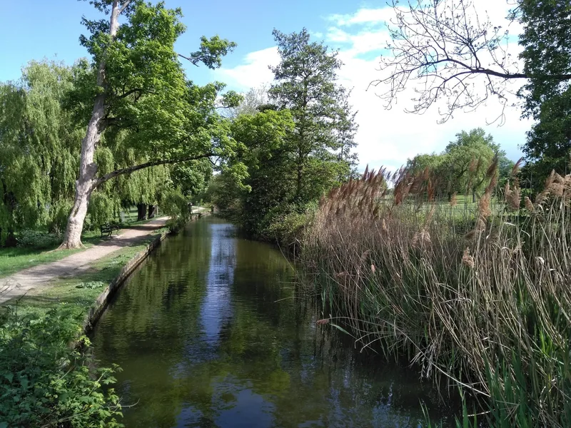
Photo: James Cracknell · CC BY-SA 4.0 · Wikimedia Commons · resized
The London stretch that is genuinely good: Enfield to Wood Green
The best walking inside London is the northern half, between Enfield and Wood Green, where the channel is open water with grass either side and the surroundings stay out of the way. Our guide to Enfield Town and the Lea valley edge covers getting to that end.
Two things on this stretch are listed buildings, and both are easy to walk past without noticing. At Hornsey and Wood Green the channel disappears into two brick tunnels; the entrance on the north side of Myddelton Road, N8, is listed Grade II and described in its list entry as an early-to-mid-nineteenth-century arch of stock brick with a high parapet, curved abutments, stone coping and square piers with flat stone caps. Stand at the parapet and you can see the water vanish.
Further south, the channel runs past the back of Finsbury Park before turning east for Woodberry Down. Our page on Angel and Finsbury Park has the neighbourhood around that end, and the path is one of the few routes in the area with no road crossings for long stretches, which is why runners use it; see our running routes in London for how it fits into a training week.
Manor House is the single best station for a short New River walk. Oxford Circus to Manor House takes 13 minutes and costs £3.10 off-peak on contactless, changing at Finsbury Park. From the station it is a nine-minute walk to the Lordship Road gate, where the path, the reservoir and a café all meet.
Woodberry Down: the New River at its most useful
If you have an hour rather than a day, walk this bit. The path runs along the top of the old reservoir bank between Manor House and Stoke Newington, with the channel on one side and open water on the other, and you can step off it into Woodberry Wetlands for nothing.
The history is legible here in a way it is not elsewhere. The two Stoke Newington reservoirs were built in 1833 by the same New River Company, to supply what were then the suburban towns of Stoke Newington and Stamford Hill. The large villas that went up along the channel between 1850 and 1920 made Woodberry Down an early stockbroker belt; the post-war estate that replaced them was built along the northern bank to rehouse families from Shoreditch, Bethnal Green and the docks.
Between 1955 and 1980 the reservoirs and the New River were dosed with chlorine and sodium phosphate to keep the water clean, and the water was effectively lifeless. That treatment stopped after the 1992 campaign, which is why there are now reed warblers, bitterns in winter and great crested grebes where there were none.
The Castle, and where the working river stops
At Green Lanes the path passes a building that looks like a Scottish castle and is nothing of the kind. It is the engine house of the Metropolitan Water Board, listed Grade II* since 1972, along with an ancillary building to the north; it now houses a climbing centre. The Long Distance Walkers Association uses it as the marker for the end of the working river and the start of the final section.
South of here the original channel has been filled in. The last three miles are a designated Heritage Section which follows the historic course through parks, along back streets and across Stoke Newington, before dropping down through Islington. Two survivals in Islington are worth slowing down for: the strip of gardens along Colebrooke Row and Duncan Terrace traces the old line exactly, and the raised ground at Islington Green carries a statue of Myddelton himself.
New River Head, and the surprise at the end
The path ends at New River Head, off Myddelton Passage in Clerkenwell, where the water arrived for three centuries. Until recently this was an anticlimax: the big building here is the former Metropolitan Water Board headquarters, listed Grade II* since 1950 and long since converted into flats, with a doorway inscription reading "ERECTED BY THE METROPOLITAN WATER BOARD ON THE SITE OF THE NEW RIVER HEAD" and the dates 1613 and 1920 carved beside it. You cannot go in. Its Grade II* status rests largely on an oak-panelled room of 1693, moved here from the old water house in 1919 and now private.
What has changed is next door. The Quentin Blake Centre for Illustration opened in the former waterworks buildings at 1 Myddelton Passage, EC1R 1AG, with three galleries, and is open Wednesday to Sunday, 10am to 5pm, last entry to exhibitions 4pm. The path through the site, between Myddelton Passage and Amwell Street, is open 9.30am to 5.30pm on those same five days. Exhibitions are ticketed and can be booked ahead or on the day; free spaces and a café are part of the site.
Two other listed things survive in the grounds. There is the base of a windmill, Grade II, about 12 metres across, red brick laid in English bond with a conical tiled roof and a small circular lantern at its apex; and the Devil's Conduit, a stone chimney conduit sitting in the old round reservoir pound, also Grade II.
The path is not open at all hours at the Clerkenwell end. The final few hundred metres run through the Quentin Blake Centre's site, which closes on Mondays and Tuesdays and locks at 5.30pm. Arrive on a Monday evening and you will have to finish on Amwell Street and River Street instead.
Walking the whole thing, and the gap near Hertford
The full 28 miles divides neatly into three days, or into two long ones for anyone used to walking. The Hertfordshire half is the prettier: chalk-stream water, open fields, and a run of small listed bridges and New River Company boundary markers between Ware and Amwell.
There is one long-standing obstruction. The Long Distance Walkers Association records that the path is blocked where it crosses the railway east of Hertford, and gives the workaround: follow the River Lee instead between King's Meads and the road bridge in Ware. Plan that section before you set out rather than at the fence.
Trains make the northern end easy. Liverpool Street to Hertford East takes 49 minutes with no changes, and the cheapest single on a weekday off-peak morning was £13.80 when we checked for 1 October 2026. That is outside the contactless area, so buy a ticket.
| Section | Rough length | Get on and off at | Verdict |
|---|---|---|---|
| Hertford to Ware | 3 miles | Hertford East, Ware (both Greater Anglia) | The best countryside, and the section with the railway obstruction |
| Ware to Cheshunt | 9 miles | Ware, Cheshunt (Weaver line) | Quiet, long, and short of places to stop |
| Enfield to Wood Green | 6 miles | Enfield Chase, Bowes Park, Wood Green | The best of the London channel, with the two tunnel mouths |
| Wood Green to Stoke Newington | 4 miles | Manor House, Stoke Newington | Woodberry Wetlands and the reservoir bank. The one-hour option |
| Heritage Section | 3 miles | Stoke Newington to Angel | Half street walking, and an open gallery at the end |
Rules, closures and the best months
Some sections are permissive paths for walkers rather than rights of way, which means Thames Water can and does close them for operational work. The £6.3m rebuilding of a 778-metre length alongside Eade Road, in north London, finished in March 2025 and the site was handed back to the public that June; expect something similar somewhere along the line most years.
Safety notices along the fence are not decorative. The channel is deeper and colder than it looks and the sides are smooth. There is no swimming anywhere in it.
For walking, late September to early November is the sweet spot: the water is clear, the channel is visible through thin hedges, and the London sections drain well. High summer is the worst — nettles, low water and no shade on the reservoir bank. Winter is fine as far as light allows, but the Heritage Section involves street walking that is much less pleasant in the dark.
Is it worth the journey?
For one section, yes, emphatically, and it is free: Manor House to Stoke Newington along the reservoir bank, with Woodberry Wetlands attached, is among the best short walks in north London and belongs on any list of free things to do in London.
For the middle miles between Ware and Cheshunt, be honest with yourself. It is a long, level, unremarkable walk beside a fence, with few cafés and fewer stations, and most visitors to London have better uses for a day. If you want water and open space out that way, the Lee Valley Regional Park runs parallel to it with far more to do, and Walthamstow Wetlands is the bigger reserve at the southern end of the same water system.
And for the Clerkenwell end: go for the gallery and treat the aqueduct history as the bonus. A locked Grade II* block of flats is not a destination; three galleries in the old waterworks beside it are. Two other small urban reserves make the same argument in a different part of town — Camley Street Natural Park behind King's Cross, and Abney Park Cemetery, ten minutes off the Heritage Section.
Frequently asked questions
Is the New River a real river?
No. It is a man-made channel, completed in 1613, cut to carry water from Hertfordshire springs into London on a very gentle gradient. It still works, transferring raw water each day towards Thames Water's treatment works at Coppermills, so what you are walking beside is a piece of operating infrastructure.
Can you walk the New River Path in one day?
Only if you are used to long distances. It is 45 km, about 28 miles, and most walkers split it into two or three days using the Greater Anglia line from Liverpool Street at the northern end and the Tube and Overground in London.
Which single section should I walk if I only have a morning?
Manor House to Stoke Newington, along the old reservoir bank, with a detour into Woodberry Wetlands. It is about an hour of walking, it costs nothing, there is a café at the halfway point, and the contrast between open water and the estate above it is the whole story of the New River in miniature.
Where does the path actually end?
At New River Head, off Myddelton Passage in Clerkenwell, where the water arrived from 1613. The historic headquarters building there is private flats, but the Quentin Blake Centre for Illustration occupies the former waterworks alongside and is open to the public Wednesday to Sunday.
Is the path signposted the whole way?
Not reliably, and some stretches are permissive paths that can be diverted or closed for maintenance at short notice. Carry a map or a phone route, check for closures before a long one-way walk, and note the railway obstruction east of Hertford, which is bypassed along the River Lee to Ware.
Sources
- Long Distance Walkers Association - New River Path: length, Heritage Section and obstructions (checked September 2026)
- Thames Water - New River Aqueduct refurbishment, Eade Road (checked September 2026)
- London Wildlife Trust - History of Woodberry Wetlands and the Stoke Newington reservoirs (checked September 2026)
- Historic England - New River Head, former Metropolitan Water Board offices, Grade II* (checked September 2026)
- Historic England - Windmill base, New River Head, Grade II (checked September 2026)
- Historic England - Tunnel entrance to the New River, Myddelton Road N8, Grade II (checked September 2026)
- Quentin Blake Centre for Illustration - opening hours and access at New River Head (checked September 2026)
- Transport for London - Tube and rail fares (checked September 2026)