
Spitalfields is the small district just east of Liverpool Street station, between Bishopsgate and Brick Lane, and it is the best place in London to see the streets of the early 18th century as they were built: rows of brick houses put up for Huguenot silk weavers, with wide attic windows that lit their looms. It is free to walk, takes about an hour and a half on foot, and is at its quietest on a weekday morning and its busiest on a Sunday.
The area took its name from the medieval priory and hospital of St Mary Spital, whose fields lay outside the City wall. In the late 17th and 18th centuries French Protestant refugees, the Huguenots, settled here and made it the centre of London's silk industry. Later came Irish weavers, then Jewish families from eastern Europe, then, from the mid-20th century, Bangladeshi families. One building on Brick Lane has served all of these communities in turn.
Several buildings in Spitalfields have pages of their own: Christ Church and Hawksmoor's other churches, Dennis Severs' House and the Spitalfields and Brick Lane markets. This page is about the streets between them.
Spitalfields at a glance
- Where
- London E1, borough of Tower Hamlets, at the eastern edge of the City
- Stations
- Liverpool Street (about 5 minutes' walk); Shoreditch High Street and Aldgate East (both about 10 minutes)
- Cost
- Free to walk; the streets are public
- Time
- About 90 minutes for the walk below, without going inside anything
- Best time
- Weekday mornings for the streets; Sundays for the markets
- Listed buildings
- About 135 list entries in and around the area, among them Christ Church (Grade I) and 56 Artillery Lane (Grade I)
Fournier Street: the weavers' houses at their best
Fournier Street runs east from Christ Church to Brick Lane, and it is the street to walk first. Almost every house on both sides is a listed early-18th-century terrace house: brown or yellow brick, three storeys over a basement, with an attic on top. Historic England's list entry for number 29 records a "weatherboarded attic", the wooden-clad top storey that is the clue to what these houses were for.
Look up, not at the doors. The deep attics with long rows of windows were workshops, where the light needed for weaving silk on a hand loom could reach the full width of the room. On some houses the attic windows run almost the whole width of the front. The doors themselves are worth a second look too: carved wooden doorcases with brackets, and on several houses the original wooden shutters.
The corner of Fournier Street and Commercial Street is held by the Ten Bells, a mid-19th-century pub on a site its list entry says was founded in 1666, with a coloured tiled panel of an old street scene inside the Commercial Street door. It is rated 4 for food hygiene (inspected January 2026). Christ Church Rectory at number 2 Fournier Street is listed Grade II*, a grade higher than its neighbours.
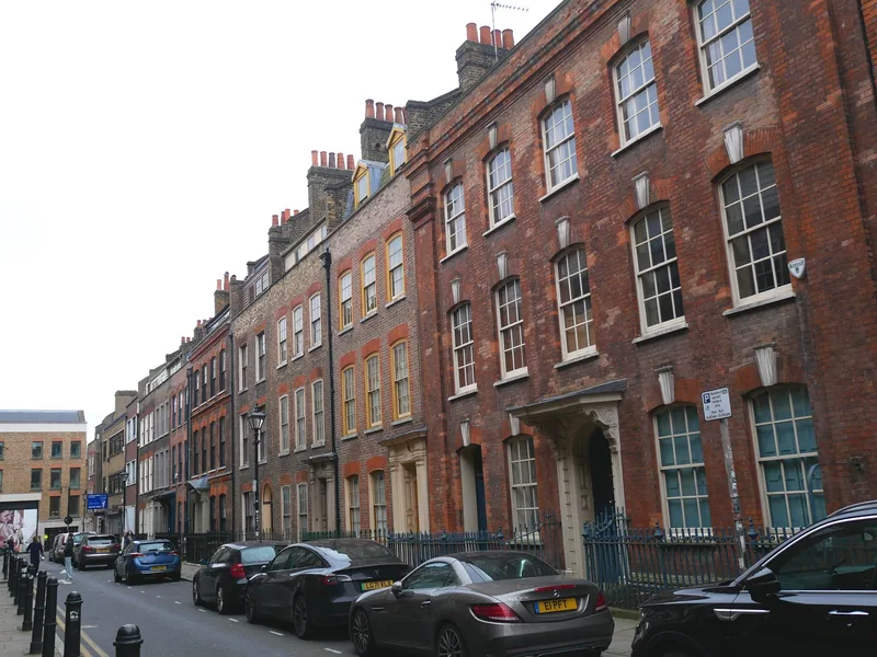
Photo: Doyle of London · CC BY-SA 4.0 · Wikimedia Commons · resized
The building with three religions
At the far end of Fournier Street, on the corner with Brick Lane, stands the Brick Lane Jamme Masjid. Historic England's list entry sets out its history. It was built in 1743-4 as the Neuve Eglise, a chapel for the French Protestant congregation, probably by Thomas Stibbs. It passed to the Wesleyan Methodists in 1819, and in 1897 it was bought by a Lithuanian Orthodox Jewish group and became the Spitalfields Great Synagogue. After the Jewish community moved to the suburbs, it became a mosque in 1976.
The list entry calls this "a uniquely complex instance" of reusing a place of worship, and it is listed Grade II* for it. From the street you can see the main survival of the first building: high on the Fournier Street front, inside the triangular pediment, a sundial dated 1743 with the Latin motto Umbra sumus, "we are but shadow". The tall steel structure on the Brick Lane corner, about 29 metres high and meant to recall a minaret, was added in 2009.
It is a working mosque, not a visitor attraction, and we could not find published visiting arrangements; look at it from the street and do not photograph worshippers. For a mosque that does welcome visitors, our page on the East London Mosque on Whitechapel Road explains how.
Read the sundial from across Fournier Street. The mosque's long front faces south onto the street, so stand on the south pavement, by the houses opposite, and look up at the pediment: the date and the motto are in the centre, above the two doorways.
Princelet Street and Wilkes Street: the quieter pair
Princelet Street runs parallel to Fournier Street, one block north, and Wilkes Street crosses both of them; on a weekday they can be almost empty. Wilkes Street's west side, numbers 17 to 25, is a listed early-18th-century row with Doric doorcases.
Number 19 Princelet Street is the most remarkable house in the area, though you will usually see only its front. Its list entry, Grade II*, describes a terrace house of 1719 by the builder Samuel Worrall, with a weavers' attic lit by a seven-bay window of leaded lights. In 1870 a synagogue was built in what had been its garden, with a ladies' gallery and an ark, and much of it survives behind the plain front. The building is very rarely open; when it is, it is usually announced only a short time ahead.
Hanbury Street, one block north, mixes houses of the same period with later workshops and shops. Brick Lane itself, at the end of each of these streets, has a terrace of five early-18th-century houses at numbers 114 to 122, refaced around 1795, with garret windows in the roof.
Elder Street, Folgate Street and the northern edge
North of the market, across Commercial Street, Elder Street and Folgate Street form a second group of the same houses. Historic England dates numbers 19 and 21 Elder Street to about 1720, and the road surface of Elder Street is itself part of the listed group. Folgate Street holds Dennis Severs' House, which needs booking and is covered on its own page.
Spital Square, the small open space between Folgate Street and the market, keeps just one 18th-century house, number 37, with its railings. Almost everything else around the square is modern office building, which shows how much of the old district has been rebuilt.
Artillery Lane and the shopfront on the list
South-west of the market, between Bishopsgate and Commercial Street, a narrow passage called Artillery Passage leads into Artillery Lane. The name comes from the artillery ground that used to be here, where the City's gunners practised.
The reason to come is number 56 Artillery Lane. It is one of only two Grade I buildings in this part of Spitalfields, alongside Christ Church, and it is listed for a mid-18th-century wooden Doric shopfront with two flattened bow windows and carved door surrounds. Shopfronts of that age are rare survivals in London; our guide to London's oldest shops has others of the same age.
Nearby, Sandys Row Synagogue is a working synagogue in a building that opened in 1766 as a French Protestant church, according to its list entry, and still has its 18th-century gallery inside.
The market hall, and what lies under Bishops Square
Old Spitalfields Market, the covered hall between Commercial Street and Bishops Square, is the centre of the district. Its listed Victorian buildings, on the Commercial Street, Lamb Street and Brushfield Street sides, were designed by George Sherrin and built between 1885 and 1893 for the market's last private owner, Robert Horner (Historic England's list entry spells the name "Homer"). Look for the dates 1885 and 1886 on the rainwater heads. For what is on sale each day, see our guide to the markets.
Under and around the old market site, the archaeologists of MOLA excavated the medieval priory and hospital of St Mary Spital, which is a scheduled monument, recording around 10,500 Roman and medieval burials. Part of what they found has been left on show in Bishops Square: the stone remains of the priory's charnel house, the building where bones from the cemetery were kept, can be seen from street level through glass. It costs nothing.
We could not find an official source that publishes when the steps down to the viewing window are open, so treat that part as something you may or may not find open. The view through the glass from above is always there.
A walk that links it all, in about 90 minutes
This route starts and ends near Liverpool Street and does not repeat any street. Times are our estimate at an easy pace, without going inside.
- Liverpool Street station to Artillery Lane (5 minutes): cross Bishopsgate and turn into Artillery Lane, then look into the narrow Artillery Passage. Look at the shopfront at 56 Artillery Lane.
- To Bishops Square (5 minutes): north to the charnel house glass in Bishops Square, then through the market hall.
- Spital Square, Folgate Street and Elder Street (15 minutes): north across Spital Square, east along Folgate Street, and north up Elder Street.
- Back to Christ Church (10 minutes): down Commercial Street. The church is the white tower you can see from Elder Street.
- Fournier Street to Brick Lane (15 minutes): slowly, with the sundial at the end.
- Princelet Street, Wilkes Street and Hanbury Street (15 minutes): a loop north and back.
- Brick Lane south (15 minutes): past the curry houses to Aldgate East station, or back west to Liverpool Street.
On a Sunday, do it the other way round and finish at the markets; on a weekday, the order above gets you to Fournier Street before the office lunch crowds.
When to come, and what changes on a Sunday
Spitalfields has two characters. From Monday to Friday the western half, around the market and Bishops Square, is full of office workers at lunchtime and quiet early and late, while Fournier Street and its neighbours are peaceful all day. That is the best time to look at the houses.
On Sunday the whole area fills up. The Brick Lane markets, Old Spitalfields and, a 15-minute walk north-east, Columbia Road Flower Market all trade, and the pavements of Brick Lane can be hard to walk along by late morning. Christ Church usually opens to visitors on Sunday afternoons; check its own page before you plan around it. Go early, from about 09:00, if you want both the streets and the stalls.
The whole walk is free. Nothing on the route above charges for entry. The only things that cost money are Dennis Severs' House, which must be booked, and whatever you eat on Brick Lane.
Eating, and where the area meets its neighbours
Brick Lane's food has two halves. The southern end is the curry street, and our guide to Brick Lane and London's curry houses explains how to choose one. The northern end, past the old Truman Brewery, is where the 24-hour bagel bakeries are; see salt beef, bagels and Jewish London for the story behind them.
North of Spitalfields is Shoreditch, with its street art and nightlife. To the south and east, Brick Lane leads into Whitechapel; our guide to Whitechapel and the East End picks up where this one stops, and staying in Whitechapel and Aldgate covers hotels a few minutes from these streets.
Spitalfields is also a good last morning in London if you are flying from Stansted: Liverpool Street, where the Stansted Express leaves, is five minutes from the market. Our page on planning the departure day explains how to fit it in.
Frequently asked questions
What is Spitalfields known for?
Spitalfields is known for its early-18th-century houses built for Huguenot silk weavers, Hawksmoor's Christ Church, Old Spitalfields Market and the Brick Lane Jamme Masjid, a building that has been a Huguenot chapel, a Methodist chapel, a synagogue and a mosque.
Is Brick Lane Mosque really a former church and synagogue?
Yes. Historic England records that it was built in 1743-4 as a French Protestant chapel, passed to the Wesleyan Methodists in 1819, became the Spitalfields Great Synagogue in 1897 and became a mosque in 1976.
Where are the Huguenot houses in Spitalfields?
The best-preserved are on Fournier Street, Princelet Street and Wilkes Street, between Christ Church and Brick Lane, and on Elder Street and Folgate Street north of the market. Look for the wide attic windows that lit the silk looms.
How do I get to Spitalfields?
Liverpool Street station, on the Elizabeth line, the Central line and several others, is about five minutes' walk away. Shoreditch High Street on the Overground and Aldgate East on the District and Hammersmith & City lines are both about ten minutes away.
Is Spitalfields worth visiting on a weekday?
Yes, especially for the streets. The houses are easier to see and photograph when the markets are quiet, and Old Spitalfields Market is open every day. Come on Sunday instead if the markets are the main reason for your visit.
Sources
- Historic England - Brick Lane Jamme Masjid (former Neuve Eglise), list entry 1240697 (checked November 2026)
- Historic England - Spitalfields Market, list entry 1065750 (checked November 2026)
- Historic England - 19 Princelet Street, list entry 1260421 (checked November 2026)
- Historic England - 56 Artillery Lane, list entry 1357760 (checked November 2026)
- Historic England - Priory and Hospital of St Mary Spital, scheduled monument 1001982 (checked November 2026)
- MOLA - Spitalfields: archaeology, regeneration and public benefit (checked November 2026)
- Food Standards Agency - Food hygiene ratings: The Ten Bells, E1 6LY (checked November 2026)